Miscellaneous Maps, Charts & Sections
-
Books & Reports
- Reports of Investigations
- Guidebooks
- Udden Series
- Geological Circulars
- Down To Earth
- Atlases of Major Oil and Gas Reservoirs
- Texas Memorial Museum Publications
- Environmental Geologic Atlas of the Texas Coastal Zone
- Mineral Resource Circulars
- Other Reports
- Seminars and Workshops
- Handbooks
- Submerged Lands of Texas
- Symposia
- Annual Reports
- Open File Reports
-
Maps & Cross Sections
- Thematic Maps
- Miscellaneous Maps, Charts & Sections
- Geologic Atlas of Texas
- STATEMAP Project Maps
- Geologic Quadrangle Maps
- Cross Sections
- Highway Geology Map
- Energy and Mineral Resource Maps
- Shoreline Change and Other Posters
- Wilcox Group, East Texas, Geological / Hydrological Folios
- Bouguer Gravity Atlas of Texas
- River Basin Regional Studies
- Featured Maps
- Posters
- Teachers & the Public
-
Geological Society Publications
- Gulf Coast Association of Geological Societies
- Alabama Geological Society
- Austin Geological Society
- Corpus Christi Geological Society
- Houston Geological Society
- Lafayette Geological Society
- Mississippi Geological Society
- New Orleans Geological Society
- South Texas Geological Society
- GCS SEPM Publications
- Historic BEG & UT Series


Geologic Map of Mariscal Mountain, Big Bend National Park, Texas
MM0048
For a downloadable, digital version: MM0048D.
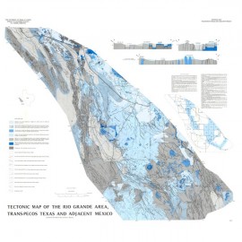
MM0048. Geologic Map of Mariscal Mountain, Big Bend National Park, Texas, by P. W. Dickerson, W. R. Muehlberger, and E. W. Collins. Oversize color map, scale 1:24,000, 2010.
To purchase this publication as a PDF download, please order MM0048D.
About This Publication
The Mariscal Mountain area is located in the Rio Grande bend, in southernmost Big Bend National Park. It straddles the border between Texas and Coahuila, Mexico.
Portrayed in this geologic map as well as in four cross sections and selected field photos, are the results of at least eight tectonic and magmatic events that occurred in this area in Cretaceous and post-Cretaceous time. Principal observations: (1) Post-K rhyolite and basalt are thrust faulted in the nose of the Mariscal anticline. (2) A range-parallel thrust fault in central Mariscal Canyon is cut by north- and west-striking normal faults. (3) A major left-lateral strike-slip fault and probable flower structure are exposed in the east-central Canyon. (4) Previously unmapped rhyolite ignimbrite and Del Carmen Formation (oldest Cretaceous rocks in the park) are now documented. (5) Solution-collapse features are common in folded, faulted, and fractured Lower Cretaceous carbonate rocks—Boquillas Formation and rhyolite sills have foundered into one approximately 0.3-km sinkhole on the eastern mountain flank.
The map was compiled using field and aerial-photograph interpretations and with the assistance of staffers from the National Park Service and Bureau of Economic Geology and Department of Geological Sciences at The University of Texas at Austin. It is the first geologic map of the area to be constructed on a topographic base.
Keywords: maps, geologic maps, Big Bend National Park, parks, national parks, Mariscal Mountain, San Vicente Mountain, Texas
Citation
Dickerson, P. W., Muehlberger, W. R., and Collins, E. W., 2010, Geologic Map of Mariscal Mountain, Big Bend National Park, Texas: The University of Texas at Austin, Bureau of Economic Geology Miscellaneous Map No. 48, map scale 1:24,000.