
Contents:
Vapor-Plume Deposits, K–Pg Boundary Outcrop in the Village of Armenia, Belize
David T. King, Jr. and Lucille W. Petruny
Facies Variability in Paleogeographic Trends from Core Data in the Lower and Middle Frio Formation in South Texas
Harold H. Rogers, III and William A. Ambrose


Lowstand valley fill and shelf-edge deltaic deposits in the Tannehill sandstone (Wolfcampian Cisco Group) in the Eastern Shelf of the Permian Basin are major targets for oil and gas exploration. The most-productive trends link coarse-grained alluvial systems in Baylor County to shelf-edge and upper-slope deepwater systems in Dickens County.
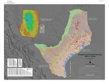
This 1:1,000,000 scale map shows salt dome locations and salt bed structure in onshore Texas. The GeMS GIS database contains structure contours for both domes and bedded salt. Source data include structure contour maps between scales of 1:2,000 and 1:24,000 published between 1925 and 2021. The source map contours were interpreted from well data and geophysical measurements including seismic, gravimetric, and magnetic. Contour intervals vary depending on source data; all represent salt structure elevations relative to mean sea level (MSL).