Geologic Maps Publications
|
Title |
Publication Year
Sort ascending
|
Abstract |
Author |
Series |
Publisher |
|
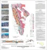
Geologic map of the Southern Franklin Mountains, El Paso, Texas, with focus on collapse breccia |
2010 |
|
Lucia, F.J. |
Miscellaneous Map |
Bureau of Economic Geology |

|
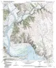
Geologic map of the Brazos Point quadrangle, Texas |
2010 |
|
Collins, E.W. |
Open-File Map |
Bureau of Economic Geology |
|
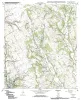
Geologic map of the Lakeside Village quadrangle, Texas |
2010 |
|
Collins, E.W. |
Open-File Map |
Bureau of Economic Geology |
|
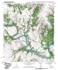
Geologic map of the Blanton quadrangle, Texas |
2010 |
|
Collins, E.W. |
Open-File Map |
Bureau of Economic Geology |
|
Geologic map of the Hillsboro West quadrangle, Texas |
2010 |
|
Collins, E.W. |
Open-File Map |
Bureau of Economic Geology |
|
Geologic map of the Keene quadrangle, Texas |
2010 |
|
Collins, E.W. |
Open-File Map |
Bureau of Economic Geology |
|
Geologic map of the Blum quadrangle, Texas |
2009 |
|
Collins, E.W. |
Open-File Map |
Bureau of Economic Geology |
|
Geologic Map of the Covington quadrangle, Texas |
2009 |
|
Collins, E.W. |
Open-File Map |
Bureau of Economic Geology |
|
Geologic Map of the Files Valley quadrangle, Texas |
2009 |
|
Collins, E.W. |
Open-File Map |
Bureau of Economic Geology |
|
Geologic map of the Itasca quadrangle, Texas |
2009 |
|
Collins, E.W. |
Open-File Map |
Bureau of Economic Geology |