|
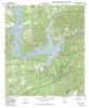
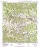
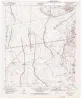
Geologic map of the Medina Lake Quadrangle, Texas |
1995 |
|
Collins, E.W. |
Open-File Map |
Bureau of Economic Geology |
|
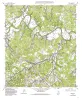
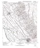
Geologic map of the Helms West Well Quadrangle, Texas |
1995 |
|
Collins, E.W., Raney, J.A. |
Open-File Map |
Bureau of Economic Geology |
|
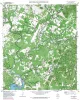
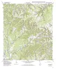
Geologic map of the Pipe Creek Quadrangle, Texas |
1995 |
|
Collins, E.W. |
Open-File Map |
Bureau of Economic Geology |
|
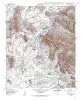
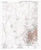
Geologic map of the Hueco Tanks Quadrangle, Texas |
1995 |
|
Collins, E.W., Raney, J.A. |
Open-File Map |
Bureau of Economic Geology |
|
Geologic map of the Ranger Creek Quadrangle, Texas |
1995 |
|
Collins, E.W. |
Open-File Map |
Bureau of Economic Geology |
|
Geologic map of the Waring quadrangle, Texas |
1995 |
|
Collins, E.W. |
Open-File Map |
Bureau of Economic Geology |
|
Geologic map of the Turkey Knob quadrangle, Texas |
1995 |
|
Collins, E.W. |
Open-File Map |
Bureau of Economic Geology |
|
Geologic map of the Nations East Well quadrangle, Texas |
1995 |
|
Collins, E.W. |
Open-File Map |
Bureau of Economic Geology |
|
Geologic map of the Nations South Well quadrangle, Texas |
1995 |
|
Collins, E.W. |
Open-File Map |
Bureau of Economic Geology |
|
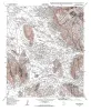
Geologic map of the Clint quadrangle, Texas |
1995 |
|
Collins, E.W., Raney, J.A. |
Open-File Map |
Bureau of Economic Geology |