STATEMAP Project Maps
-
Books & Reports
- Reports of Investigations
- Guidebooks
- Udden Series
- Geological Circulars
- Down To Earth
- Atlases of Major Oil and Gas Reservoirs
- Texas Memorial Museum Publications
- Environmental Geologic Atlas of the Texas Coastal Zone
- Mineral Resource Circulars
- Other Reports
- Seminars and Workshops
- Handbooks
- Submerged Lands of Texas
- Symposia
- Annual Reports
- Open File Reports
-
Maps & Cross Sections
- Thematic Maps
- Miscellaneous Maps, Charts & Sections
- Geologic Atlas of Texas
- STATEMAP Project Maps
- Geologic Quadrangle Maps
- Cross Sections
- Highway Geology Map
- Energy and Mineral Resource Maps
- Shoreline Change and Other Posters
- Wilcox Group, East Texas, Geological / Hydrological Folios
- Bouguer Gravity Atlas of Texas
- River Basin Regional Studies
- Featured Maps
- Posters
- Teachers & the Public
-
Geological Society Publications
- Gulf Coast Association of Geological Societies
- Alabama Geological Society
- Austin Geological Society
- Corpus Christi Geological Society
- Houston Geological Society
- Lafayette Geological Society
- Mississippi Geological Society
- New Orleans Geological Society
- South Texas Geological Society
- GCS SEPM Publications
- Historic BEG & UT Series


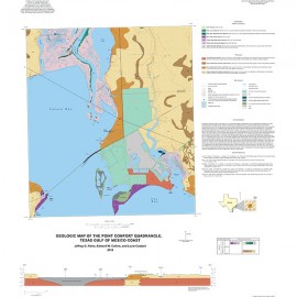
Port O'Connor Quadrangle, Texas
OFM0224
For a downloadable, digital version: OFM0224D.
OFM0224. Geologic Map of the Port O'Connor Quadrangle, Texas Gulf of Mexico Coast, by J. G. Paine and E. W. Collins. Oversize geologic map on a color topographic base, map scale 1:24,000, and sheet 2: geophysical logs and time-domain electromagnetic induction soundings, 2016. Paper format. For PDF: OFM0224D.
About This Map
This map illustrates the geology at the western margin of Matagorda Bay and the recently established Texas Parks and Wildlife Powderhorn Ranch conservation area. The area’s geology consists of sediments deposited within a Pleistocene barrier system and Holocene bay-estuary and barrier systems. The map illustrates Pleistocene units that represent four phases of Ingleside barrier deposition and compose much of the map area. The map also displays Holocene bay margin–beach, tidal-flat, and spit deposits. Man-made features identified include selected channels, pits, dredged-material disposal areas, selected areas artificially elevated by fill material, and jetties. Subsurface data are displayed in sheet 2: geophysical logs and time-domain electromagnetic induction soundings.
Citation
Paine, J. G., and Collins, E. W., 2016, Geologic Map of the Port O'Connor Quadrangle, Texas Gulf of Mexico Coast: The University of Texas at Austin, Bureau of Economic Geology, Open-File Map No. 224, map scale 1:24,000.