STATEMAP Project Maps
-
Books & Reports
- Reports of Investigations
- Guidebooks
- Udden Series
- Geological Circulars
- Down To Earth
- Atlases of Major Oil and Gas Reservoirs
- Texas Memorial Museum Publications
- Environmental Geologic Atlas of the Texas Coastal Zone
- Mineral Resource Circulars
- Other Reports
- Seminars and Workshops
- Handbooks
- Submerged Lands of Texas
- Symposia
- Annual Reports
- Open File Reports
-
Maps & Cross Sections
- Thematic Maps
- Miscellaneous Maps, Charts & Sections
- Geologic Atlas of Texas
- STATEMAP Project Maps
- Geologic Quadrangle Maps
- Cross Sections
- Highway Geology Map
- Energy and Mineral Resource Maps
- Shoreline Change and Other Posters
- Wilcox Group, East Texas, Geological / Hydrological Folios
- Bouguer Gravity Atlas of Texas
- River Basin Regional Studies
- Featured Maps
- Posters
- Teachers & the Public
-
Geological Society Publications
- Gulf Coast Association of Geological Societies
- Alabama Geological Society
- Austin Geological Society
- Corpus Christi Geological Society
- Houston Geological Society
- Lafayette Geological Society
- Mississippi Geological Society
- New Orleans Geological Society
- South Texas Geological Society
- GCS SEPM Publications
- Historic BEG & UT Series

Bloomington SW quadrangle, Texas. Digital Download
OFM0203D
For a print version: OFM0203.
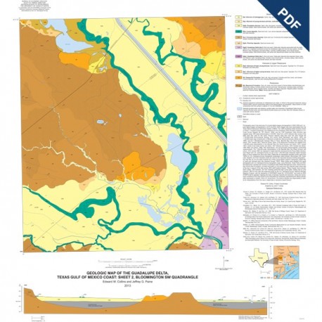
OFM0203D. Geologic Map of the Guadalupe Delta, Texas Gulf of Mexico Coast: Sheet 2−Bloomington Quadrangle, by E. W. Collins and J. G. Paine. Oversize geologic map on color topographic base, map scale 1:24,000, 2013. Downloadable PDF. For paper map: OFM0203.
To order a paper version of this map, please order OFM0203.
About This Publication
Sheet 2 of the Guadalupe River delta, the Bloomington quadrangle displays the fluvial system of the Guadalupe River, Black Bayou, San Antonio River, and Cushman Bayou where they have dissected into the Pleistocene Beaumont Formation. Point-bar, crevasse-splay, levee, terrace, and floodplain deposits are mapped.
Keywords: maps, geologic maps, Bloomington quadrangle, Guadalupe delta, Texas, Gulf of Mexico, Texas coast
Citation
Collins, E. W., and Paine, J. G., 2013, Geologic Map of the Guadalupe Delta, Texas Gulf of Mexico Coast: Sheet 2−Bloomington Quadrangle: The University of Texas at Austin, Bureau of Economic Geology, Open-File Map No. OFM0203, scale 1:24,000.


![Potential for Additional Oil Recovery in Texas [1983]. Digital Download](https://store.beg.utexas.edu/4681-tm_home_default/gc8302.jpg)