STATEMAP Project Maps
-
Books & Reports
- Reports of Investigations
- Guidebooks
- Udden Series
- Geological Circulars
- Down To Earth
- Atlases of Major Oil and Gas Reservoirs
- Texas Memorial Museum Publications
- Environmental Geologic Atlas of the Texas Coastal Zone
- Mineral Resource Circulars
- Other Reports
- Seminars and Workshops
- Handbooks
- Submerged Lands of Texas
- Symposia
- Annual Reports
- Open File Reports
-
Maps & Cross Sections
- Thematic Maps
- Miscellaneous Maps, Charts & Sections
- Geologic Atlas of Texas
- STATEMAP Project Maps
- Geologic Quadrangle Maps
- Cross Sections
- Highway Geology Map
- Energy and Mineral Resource Maps
- Shoreline Change and Other Posters
- Wilcox Group, East Texas, Geological / Hydrological Folios
- Bouguer Gravity Atlas of Texas
- River Basin Regional Studies
- Featured Maps
- Posters
- Teachers & the Public
-
Geological Society Publications
- Gulf Coast Association of Geological Societies
- Alabama Geological Society
- Austin Geological Society
- Corpus Christi Geological Society
- Houston Geological Society
- Lafayette Geological Society
- Mississippi Geological Society
- New Orleans Geological Society
- South Texas Geological Society
- GCS SEPM Publications
- Historic BEG & UT Series


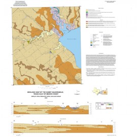
Woodsboro Quadrangle: Aransas and Mission Rivers, and Copano Bay Area, Texas Gulf of Mexico Coast
OFM0219
For a downloadable, digital version: OFM0219D.
OFM0219. Geologic Map of the Woodsboro Quadrangle, Aransas and Mission Rivers, and Copano Bay Area, Texas Gulf of Mexico Coast, by J. G. Paine, E. W. Collins, and Lucie Costard. Oversize geologic map on a color topographic base, map scale 1:24,000, 2015. Paper map. For a downloadable PDF: OFM0219D.
About This Publication
This map is one of four 1:24,000-scale maps of the Aransas and Mission rivers/deltas area at Copano Bay, Texas Gulf of Mexico Coast. This study area lies within Modern to Holocene Aransas and Mission fluvial–deltaic and bay–estuary settings. Here, the Aransas and Mission River valleys dissect Pleistocene fluvial–deltaic deposits of the Beaumont and Lissie Formations. The map of the Woodsboro Quadrangle depicts the geology for parts of the Aransas and Mission River valleys a short distance upstream from where the Aransas and Mission Deltas prograded into Copano Bay during the mid- to late Holocene. The maps illustrate a variety of geologic elements, including (1) floodplain alluvium, (2) valley-margin deposits, (3) levee deposits, (4) crevasse-splay deposits, (5) abandoned-channel deposits, (6) point-bar deposits, (7) channelbar deposits, (8) terrace alluvium, (9) upper Pleistocene Beaumont Formation deposits with some areas composed of sand-rich channel facies, and (10) Pleistocene Lissie Formation deposits.
Keywords: maps, geologic maps, quadrangle maps, Woodsboro quadrangle, Aransas River area, Mission River area, Copano Bay, Texas coast
Citation
Paine, J. G., Collins, E. W., and Costard, Lucie, 2015, Geologic Map of the Woodsboro Quadrangle, Aransas and Mission Rivers, and Copano Bay Area, Texas Gulf of Mexico Coast: The University of Texas at Austin, Bureau of Economic Geology, Open-File Map No. O219, map scale 1:24,000.