Thematic Maps
-
Books & Reports
- Reports of Investigations
- Guidebooks
- Udden Series
- Geological Circulars
- Down To Earth
- Atlases of Major Oil and Gas Reservoirs
- Texas Memorial Museum Publications
- Environmental Geologic Atlas of the Texas Coastal Zone
- Mineral Resource Circulars
- Other Reports
- Seminars and Workshops
- Handbooks
- Submerged Lands of Texas
- Symposia
- Annual Reports
- Open File Reports
-
Maps & Cross Sections
- Thematic Maps
- Miscellaneous Maps, Charts & Sections
- Geologic Atlas of Texas
- STATEMAP Project Maps
- Geologic Quadrangle Maps
- Cross Sections
- Highway Geology Map
- Energy and Mineral Resource Maps
- Shoreline Change and Other Posters
- Wilcox Group, East Texas, Geological / Hydrological Folios
- Bouguer Gravity Atlas of Texas
- River Basin Regional Studies
- Featured Maps
- Posters
- Teachers & the Public
-
Geological Society Publications
- Gulf Coast Association of Geological Societies
- Alabama Geological Society
- Austin Geological Society
- Corpus Christi Geological Society
- Houston Geological Society
- Lafayette Geological Society
- Mississippi Geological Society
- New Orleans Geological Society
- South Texas Geological Society
- GCS SEPM Publications
- Historic BEG & UT Series
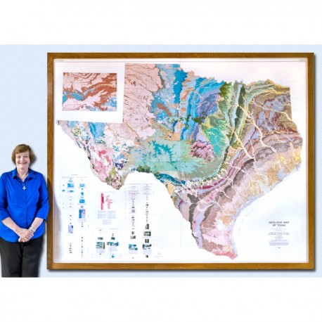
Geologic Map of Texas (4 sheets)
SM0003
Geologic Map of Texas. V. E. Barnes, compiler. Four oversized color sheets, scale 1:500,000, 1992. Each sheet measures 3.6 x 4.3 ft; if assembled together finished size is 7.2 x 8.6 ft. Sold as a set. Print Version.
For a downloadable, digital version: SM0003D.
This large, 4-sheet geologic map displays more than 350 lithostratigraphic units ranging in age from Precambrian to Quaternary. In addition to the bedrock and unconsolidated surficial units, the map shows many major cultural features, such as county boundaries, cities, state and federal highways, and railroad lines. The map is shipped unfolded in a large map tube.
Citation:
Barnes, V. E., compiler, 1992, Geologic Map of Texas: The University of Texas at Austin, Bureau of Economic Geology, State Map SM 3, 4 sheets, map scale 1:500,000.

