Reports of Investigations
-
Books & Reports
- Reports of Investigations
- Guidebooks
- Udden Series
- Geological Circulars
- Down To Earth
- Atlases of Major Oil and Gas Reservoirs
- Texas Memorial Museum Publications
- Environmental Geologic Atlas of the Texas Coastal Zone
- Mineral Resource Circulars
- Other Reports
- Seminars and Workshops
- Handbooks
- Submerged Lands of Texas
- Symposia
- Annual Reports
- Open File Reports
-
Maps & Cross Sections
- Thematic Maps
- Miscellaneous Maps, Charts & Sections
- Geologic Atlas of Texas
- STATEMAP Project Maps
- Geologic Quadrangle Maps
- Cross Sections
- Highway Geology Map
- Energy and Mineral Resource Maps
- Shoreline Change and Other Posters
- Wilcox Group, East Texas, Geological / Hydrological Folios
- Bouguer Gravity Atlas of Texas
- River Basin Regional Studies
- Featured Maps
- Posters
- Teachers & the Public
-
Geological Society Publications
- Gulf Coast Association of Geological Societies
- Alabama Geological Society
- Austin Geological Society
- Corpus Christi Geological Society
- Houston Geological Society
- Lafayette Geological Society
- Mississippi Geological Society
- New Orleans Geological Society
- South Texas Geological Society
- GCS SEPM Publications
- Historic BEG & UT Series
Origin and Development of Playa Basins, Sources of Recharge to the Ogallala Aquifer, Southern High Plains, Texas and NM
RI0229
For a downloadable, digital version: RI0229D.
RI0229. Origin and Development of Playa Basins, Sources of Recharge to the Ogallala Aquifer, Southern High Plains, Texas and New Mexico, by T. C. Gustavson, V. T. Holliday, and S. D. Hovorka. 44 p., 22 figs., 4 tables, 1995. . Print.
To purchase this publication as a PDF download, please order RI0229D.
ABSTRACT
More than 20,000 playa basins have formed on the Southern High Plains of Texas and New Mexico. These small, internally drained, roughly circular to oval depressions are economically important because they collect runoff and focus recharge to the Ogallala aquifer, which is the primary domestic and agricultural source of water on the Southern High Plains.
Across the High Plains, playa basins vary greatly in size and depth, both of which, we found, are largely controlled by the texture of the sediments that host playa basins. For example, for equal amounts of rainfall, runoff is greater on clayey soils than on loams. Larger playa basins are forming in areas of poorly permeable clayey soils because of increased potential for runoff and fluvial erosion. In areas of higher runoff more sediment is removed from basin slopes and carried to the playa basin floor, where it is available for deflation.
Playa basins formed as a result of the interaction of geomorphic, pedogenic, hydrochemical, and biologic processes. Evidence of eolian processes includes lee dunes on the east side of certain playa basins, which are composed of sediment deflated from the playa basin and straightened shorelines on the east and south margins of many playa lakes. Evidence of fluvial processes includes centripetal drainage that feeds fan deltas at the playa margins. The roughly circular shape of these basins results primarily from centripetal drainage and erosion and transport of sediment to the basin floor. Other processes that may have played secondary roles in the development of playa basins include subsidence induced by dissolution of soil carbonate or of deeply buried Permian salt and eluviation or piping of surface sediments. Destruction of stabilizing vegetation by periodic flooding and of soil crusts by grazing animals probably promoted deflation of playa sediments.
Playa basins are stable landforms, which, once initiated, tend to persist in the landscape. The interbedding of Blackwater Draw and playa sediments indicates that playa basins were developing as the Quaternary Blackwater Draw was being deposited. The absence of Miocene-Pliocene Ogallala caprock calcrete beneath parts of some playa basins may indicate that as early as late Ogallala time these playa basins began to develop as solution pans on the caprock calcrete.
Development of playa basins and the long-term stability of these landforms result partly from the difference in rates of sediment accumulation in upland areas versus playas. A stable landscape prevailed on the High Plains uplands throughout much of the Quaternary and perhaps late Tertiary, preserving both eolian sediments and soil CaCO3 in interplaya areas. During the same period, although playas accumulated lacustrine sediment, relatively small amounts of eolian and deltaic sediment, and small amounts of pedogenic CaCO3, they were subject to deflation. As a result, playa basins were enlarged (deepened) relative to surrounding uplands partly by more rapid vertical accretion of sediment and soil carbonate on uplands.
The purpose of this report is to (1) present new and significant data on playa basin morphology and developmental processes, (2) critically review current hypotheses of playa basin origin and development, and (3) describe a model of the origin and development of playa basins that integrates the hydrologic, geomorphic, sedimentary, and pedogenic processes that operate in concert to form playa basins.
Keywords: erosion processes, geomorphology, High Plains, physiography, playa, playa basin, playa origin, Quaternary, recharge, sedimentation, soil development
CONTENTS
Abstract
Introduction
Geologic Setting
Age of Playa Sediments and Playa Basins
Climate
Vegetation
Recharge through Playa and Interplaya Sediments and Soil Development
Randall Clay
Arch Loam
Pullman Clay Loam and Amarillo Sandy Clay Loam
Calcic Soil Development
Playa Basin and Lee Dune Morphology
Soil Texture and Playa Basin Morphology
Playa Basin Processes
Playa Basin Morphology
Playa Morphology
Lee Dune Morphology
Lee Dune Processes
Lee Dune Soil Development
Theories of Playa Basin Origin and Development
Deflation Salt Dissolution and Subsidence
Dissolution of Calcic Soils and Calcretes
Animal Activities
Combined Depositional, Pedogenic, Geomorphic, and Hydrologic Processes
Summary
Acknowledgments
References
Figures
1. Study area location map showing textural distribution of major soil groups on the Southern and Central High Plains
2. Topographic map of playa basins and lunettes
3. Stratigraphic diagram, upper Tertiary and Quaternary units, Southern High Plains
4. West-east stratigraphic cross section A-A' of the Texas Department of Criminal Justice playa basin
5. Resultant winds for December and March
6. Percentage of hourly observations of winds 40 krnph and stronger from different directions in December and March
7. Average monthly precipitation and wind speed at Amarillo, Texas, and monthly dust frequency
8. Precipitation and pan evaporation of udic and aridic soils near Amarillo, Texas
9. Aerial photograph and topographic map of a playa basin showing fan deltas at the ends of centripetal drainage channels
10. Orientations of bearings from the center of playas to the centers of lee dune mass and normals to flattened or straightened playa sides
11. Topographic map of two roughly oval lee dunes and associated playa basins
12. Topographic map of truncated oval lee dune and associated playa basin
13. Aerial photograph mosaic and topographic map illustrating distribution of small playas along eastern Caprock Escarpment, Southern High Plains
14. North-south stratigraphic cross section B-B' showing loss of less than 200 m of salt along north margin of the Palo Duro Basin
15. Net-salt map of parts of the Permian Salado and Seven Rivers Formations
16. Distribution of playas more than 2,440 m wide
17. Topographic map of the Lake McConnell area superimposed on a structure-contour map of a subsidence basin on top of the Permian Blaine Formation
18. West-east structural and topographic cross section C-C' of a playa basin near Lane Salt Lake, New Mexico
19. Photomosaic of an excavated playa basin, South Washington Street, Amarillo, Texas
20. Topographic map of large playa basin near Bushland, Texas
21. Multiple buried soils at Blackwater Draw type section
22. Diagrammatic representation of development of a playa basin on the High Plains
Tables
1. Normal monthly precipitation, Amarillo and Lubbock, Texas, and Clovis, New Mexico
2. Definitions of playa basin and other parameters
3. Comparison of morphology of playa basins developed in clayey and loamy soils
4. Morphometric differences between playa basins in clayey and loamy soils
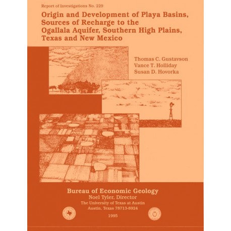
Cover: Illustrations, symbolic of the range of geologic and hydrologic processes described in this report, are (from top to bottom): eolian deposition represented by a dust storm; ground-water production represented by a windmill on the High Plains; and ground-water recharge and playa lake sedimentation represented by flooded playa lake basins on the High Plains. Cover design and line art by Jamie H. Coggin.
Citation
Gustavson, T. C., Holliday, V. T., and Hovorka, S. D., 1995, Origin and Development of Playa Basins, Sources of Recharge to the Ogallala Aquifer, Southern High Plains, Texas and New Mexico: The University of Texas at Austin, Bureau of Economic Geology, Report of Investigations No. 229, 44 p.
