Reports of Investigations
-
Books & Reports
- Reports of Investigations
- Guidebooks
- Udden Series
- Geological Circulars
- Down To Earth
- Atlases of Major Oil and Gas Reservoirs
- Texas Memorial Museum Publications
- Environmental Geologic Atlas of the Texas Coastal Zone
- Mineral Resource Circulars
- Other Reports
- Seminars and Workshops
- Handbooks
- Submerged Lands of Texas
- Symposia
- Annual Reports
- Open File Reports
-
Maps & Cross Sections
- Thematic Maps
- Miscellaneous Maps, Charts & Sections
- Geologic Atlas of Texas
- STATEMAP Project Maps
- Geologic Quadrangle Maps
- Cross Sections
- Highway Geology Map
- Energy and Mineral Resource Maps
- Shoreline Change and Other Posters
- Wilcox Group, East Texas, Geological / Hydrological Folios
- Bouguer Gravity Atlas of Texas
- River Basin Regional Studies
- Featured Maps
- Posters
- Teachers & the Public
-
Geological Society Publications
- Gulf Coast Association of Geological Societies
- Alabama Geological Society
- Austin Geological Society
- Corpus Christi Geological Society
- Houston Geological Society
- Lafayette Geological Society
- Mississippi Geological Society
- New Orleans Geological Society
- South Texas Geological Society
- GCS SEPM Publications
- Historic BEG & UT Series
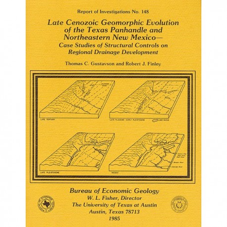
Late Cenozoic Geomorphic Evolution of the Texas Panhandle and Northeastern New Mexico
RI0148
Late Cenozoic Geomorphic Evolution of the Texas Panhandle and Northeastern New Mexico--Case Studies of Structural Controls on Regional Drainage Development, by T. C. Gustavson and R. J. Finley. 42 p., 20 figs., 1985. ISSN: 0082335X: Print Version.
A free, digital version of this publication can be found on: Texas ScholarWorks
RI0148. Late Cenozoic Geomorphic Evolution of the Texas Panhandle and Northeastern New Mexico--Case Studies of Structural Controls on Regional Drainage Development, by T. C. Gustavson and R. J. Finley. 42 p., 20 figs., 1985. ISSN: 0082335X: Print.
To purchase this publication as a downloadable PDF, please order RI0148D.
ABSTRACT
Salt dissolution has affected parts of the Upper Permian Salado, Seven Rivers, San Andres, Glorieta, and upper Clear Fork Formations beneath the Pecos River valley in eastern New Mexico and has been active beneath the Canadian River valley and the Rolling Plains of the Texas Panhandle. Extensive dissolution of the salts of the Salado and Seven Rivers Formations has also occurred beneath the Southern High Plains. Cumulative thickness of salt lost to dissolution exceeds 150 m (500 ft) along the western, northern, and eastern margins of the Palo Duro Basin. Dissolution and subsidence occurred during deposition of the Tertiary Ogallala Formation, but Ogallala deposition kept pace with subsidence. After Ogallala deposition during the late Pliocene, surface subsidence created lacustrine basins along trends of relatively rapid dissolution. Preserved lacustrine sediments contain Blancan faunas (which confirm a basin age of at least late Pliocene). Continued subsidence along trends of relatively rapid dissolution overlying the structural margins of the Palo Duro and Anadarko Basins during the late Tertiary and early Quaternary formed a series of subsidence basins that diverted many of the streams that flowed southeasterly across the Southern High Plains. As a result of subsidence, the headwaters of the ancestral Brazos River were diverted during the middle to late Pleistocene from a southeastern drainage through the Portales paleovalley to a southern drainage through the Pecos Valley. The present headwaters of the Canadian River are probably a former tributary of the Pecos-Portales-Brazos River system that was diverted to the northeast along a subsidence trough caused by dissolution during the late Pliocene or early Quaternary.
On the High Plains surface, several lacustrine basins (Frio Draw, Tierra Blanca Creek, and Yellow House Draw) lie above areas where accelerated salt dissolution has apparently occurred. These features overlie apparent structural depressions of the Alibates Formation, which is stratigraphically above the salt-bearing units. Most of the features also overlie either paleostream valleys or closed depressions on the middle Tertiary erosional surface. Faunal evidence suggests that the present stream valleys formed as early as the late Pliocene. Lacustrine basins probably formed between the late Pliocene and the early Pleistocene. The basins and stream valleys probably owe most of their form to normal fluvial and eolian erosion. Their location, however, is most likely the result of dissolution-induced subsidence.
A large system of late Quaternary alluvial fans that built eastward from the Caprock Escarpment is being extensively dissected. This suggests that much of the drainage on the Rolling Plains in the Texas Panhandle developed during the late Pleistocene and Holocene. The parallelism between major stream segments and the dissolution fronts of Permian salt-bearing units indicates that much of the drainage is controlled by dissolution-induced subsidence. Furthermore, minor stream segments parallel the preferred orientations of numerous subsidence basins that are on the surface of the alluvial fans. Both straight segments of minor streams and long axes of subsidence basins are aligned parallel to the preferred orientations of the regional fracture system. Dissolution was probably accelerated along fracture trends, resulting in the development of subsidence basins that parallel fracture trends and, in turn, leading to the alignment of drainage when subsidence basins were incorporated into the drainage network.
Keywords: geomorphology, physiography, salt dissolution, Cenozoic, Texas Panhandle, northeastern New Mexico
CONTENTS
ABSTRACT
INTRODUCTION
GEOLOGIC SETTING OF THE PALO DURO BASIN
Structural development
Sedimentation
Physiography of the Texas Panhandle and central-eastern New Mexico
PHYSIOGRAPHIC DEVELOPMENT OF EASTERN NEW MEXICO AND THE TEXAS PANHANDLE
Methods
Evidence of dissolution
Dissolution along the margins of the Southern High Plains
Dissolution beneath the Southern High Plains
Salado Formation
Seven Rivers Formation
Age of dissolution
MIDDLE TERTIARY EROSIONAL SURFACE
Southern High Plains (middle Tertiary) paleotopography
COMPARISON OF HOLOCENE SOUTHERN HIGH PLAINS DRAINAGE TO TERTIARY DRAINAGE
STRUCTURAL CONTROLS ON REGIONAL DRAINAGE DEVELOPMENT
Pecos and Canadian Rivers
Diversions of regional paleodrainage
Pecos River valley
Canadian River valley
Prairie Dog Town Fork of the Red River
Rolling Plains drainage
Subsidence basins, sinkholes, and fractures
Linear drainage elements
Relation between aligned surface elements and salt dissolution
Southern High Plains drainage
Influence of salt dissolution and subsidence on Frio Draw and Tierra Blanca Creek
Yellow House, Blackwater, and Running Water Draw/White River
Structural controls on dissolution
EVOLUTION OF REGIONAL PHYSIOGRAPHY
Miocene to early Pliocene
Late Pliocene to middle Pleistocene
Late Pleistocene Late Pleistocene to Holocene
CONCLUSIONS
ACKNOWLEDGMENTS
REFERENCES
Figures
1. Major structural elements, Texas Panhandle and surrounding areas
2. Physiography of eastern New Mexico and the Texas and Oklahoma Panhandles
3. Zones of salt dissolution in eastern New Mexico and the Texas and Oklahoma Panhandles
4. Stratigraphic cross section illustrating salt dissolution and collapse of strata beneath the Pecos River
5. Stratigraphic cross section illustrating salt dissolution and collapse of strata beneath the Canadian River
6. Stratigraphic cross section illustrating salt dissolution and collapse of overlying strata beneath Tule Creek
7. Stratigraphic cross section illustrating salt dissolution and collapse of overlying strata beneath the Palo Duro Canyon
8. Net-salt map of parts of the Salado and Seven Rivers Formations
9. Structure·conlour map on the top of the Alibates Formation
10. Structure·contour, or paleotopographic, map on the base of the Ogallala Formation
11. Structure-contour map on the top of the Alibates Formation, interpreted from seismic reflection velocity data
12. Stratigraphic section showing dissolution of Seven Rivers Formation salts and collapse of overlying strata beneath Tierra Blanca Creek
13. Regional topography in eastern New Mexico and the Texas and Oklahoma Panhandles at the end of Ogallala deposition during the late Tertiary
14. Regional drainage of eastern New Mexico and of the Texas and Oklahoma Panhandles
15. Evolution of drainage in eastern New Mexico and the Texas and Oklahoma Panhandles since the end of Ogallala deposition
16. Location of sinkholes, dolines, and fractures in Hall and eastern Briscoe Counties, Texas
17. Diagrams indicating orientations of long axes of dolines and linear stream segments in Hall County, Texas
18. Fracture orientations from surface locations in the Texas Panhandle and eastern New Mexico and from test wells in the Texas Panhandle
19. Texas and New Mexico counties, from which sinkholes and fractures have been reported, lying exclusively within a peripheral dissolution zone that encompasses the Pecos Plains, the Canadian River Breaks, and the Rolling Plains
20. Comparison of stream segments to trends of the eastern limits of Permian salts
Citation
Gustavson, T. C., and Finley, R. J., 1985, Late Cenozoic Geomorphic Evolution of the Texas Panhandle and Northeastern New Mexico--Case Studies of Structural Controls on Regional Drainage Development: The University of Texas at Austin, Bureau of Economic Geology, Report of Investigations No. 148, 42 p.
