Reports of Investigations
-
Books & Reports
- Reports of Investigations
- Guidebooks
- Udden Series
- Geological Circulars
- Down To Earth
- Atlases of Major Oil and Gas Reservoirs
- Texas Memorial Museum Publications
- Environmental Geologic Atlas of the Texas Coastal Zone
- Mineral Resource Circulars
- Other Reports
- Seminars and Workshops
- Handbooks
- Submerged Lands of Texas
- Symposia
- Annual Reports
- Open File Reports
- Maps & Cross Sections
- Posters
- Teachers & the Public
- Geological Society Publications
- Historic BEG & UT Series
Geologic Setting and Geochemistry of Thermal Water and Geothermal Assessment, Trans-Pecos Texas and Adjacent Mexico
RI0096
Geologic Setting and Geochemistry of Thermal Water and Geothermal Assessment, Trans-Pecos Texas, with Tectonic Map of Rio Grande Area, Trans-Pecos Texas and Adjacent Mexico, by C. D. Henry. 48 p., 24 figs., 5 tables, 1 plate, 1979. ISSN: 0082335X. Print Version.
A free, digital version of this publication can be found on: Texas ScholarWorks
RI0096. Geologic Setting and Geochemistry of Thermal Water and Geothermal Assessment, Trans-Pecos Texas, with Tectonic Map of the Rio Grande Area, Trans-Pecos Texas and Adjacent Mexico, by C. D. Henry. 48 p., 24 figs., 5 tables, 1 plate, 1979. ISSN: 0082335X. Print.
To purchase this publication as a downloadable PDF, please order RI0096D.
To purchase the tectonic map (scale 1:500,000) separately, please order MM0035.
ABSTRACT
Hot springs and wells in West Texas and adjacent Mexico are manifestations of active convective geothermal systems concentrated in a zone along the Rio Grande between the Quitman Mountains and Big Bend National Park. Maximum temperatures are 47°C and 72°C for hot springs and wells in Texas and 90°C for hot springs in Mexico within 5 km of the border.
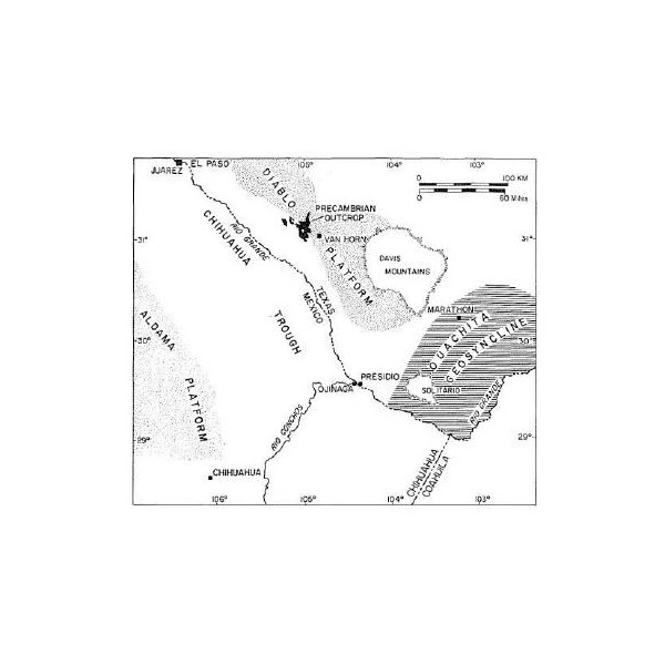
The area lies along the eastern margin of the Basin and Range province in what may be an extension of the Rio Grande Rift. The heat source for the thermal waters is deep circulation of ground water in an area of relatively high thermal gradient. Recent volcanism is not a source of heat because, based on both paleontologic and isotopic evidence, the youngest observed igneous activity in West Texas is Miocene.
Most hot springs lie on or immediately basinward of normal faults, at the edges of late Tertiary basins formed by east-west extension. This setting implies that faults are permeable channelways which allow thermal water to rise from below. Recharge for the thermal systems probably occurs in adjacent highlands. Hot springs are not restricted to faults with large displacement or to particular rock types. However, many faults do show evidence of recent movement, which may be important in keeping fracture systems permeable.
The setting of hot springs in basins composed of permeable sediments implies that, although thermal circulation could occur along other faults, the water does not discharge to the surface. For example, several wells tap hot water at depths of about 20 to 1,000 m.
The thermal waters fall generally into three chemical groups that can be related to subsurface host rocks. Waters circulating entirely within carbonate and clastic sediments contain moderate total dissolved solids composed of Ca, Mg, HCO3, and SO4. Waters from zeolitized, silicic volcanic rocks contain low to moderate total dissolved solids composed primarily of Na and HCO3. Evaporite waters have high total dissolved solids, Na, Cl, SO4, HCO3, and Li. According to their chemistry and geologic setting, evaporate waters have been in contact with evaporites and limestone. Gradation between groups indicates mixing of waters from different host rocks.
Interpretation of silica and sodium-potassium-calcium geothermometers is complicated by the geologic setting and geochemistry of thermal waters. Solution of evaporites and nonequilibrium with feldspars partly negate use of the sodium-potassium-calcium method. Solution of amorphous silica and nonequilibrium with quartz complicate use of the silica method.
The best interpretation of geothermometry indicates that there is an intermediate-temperature group of springs with maximum subsurface temperatures approximately equal to their surface temperatures-around 60°C. Three thermal systems, the two Gulf Wells in Texas and Ojos Calientes in Mexico, have higher subsurface temperatures, ranging from at least 100°C up to possibly 160°C.
According to the geologic setting and geothermometry of hot spring systems, the most promising area for geothermal energy is the Presidio Graben, an actively subsiding basin along the Rio Grande. This area has the densest concentration of hot springs and wells and the highest surface and subsurface temperatures (90°C and 160°C, respectively). The high temperatures result from deep circulation of meteoric water in a region with high thermal gradient caused by crustal thinning. Hueco Bolson south of El Paso is in a similar geologic setting, but hot springs are found in only one area and have moderate (approximately 60°C) subsurface temperatures.
Other areas are not as promising for geothermal development as Presidio and Hueco Bolsons. Although it has many hot springs, the Big Bend area has low subsurface temperatures and no evidence of recent faulting. Hot springs in Big Bend are probably a result of relatively shallow circulation in an area of normal heat flow.
The Lobo Valley area northwest of Marfa is a deep graben and has recent fault scarps and high silica concentrations in the ground water. However, there are no hot springs or wells, and the high silica content probably reflects shallow circulation through volcanic and volcaniclastic rocks containing amorphous silica. The lack of thermal water suggests normal heat flow.
Salt Basin is an active, shallow graben without hot springs; subsurface temperatures are low. It lies at the easternmost edge of the Basin and Range province and is probably underlain by a crust of normal cratonic thickness with low heat flow.
Keywords: Big Bend National Park, Big Bend, Hueco Bolson, Lobo Valley, Basin and Range, Texas, Mexico, Trans-Pecos Texas, geochemistry, geothermal, geothermometry, Salt Basin, hot springs
Citation
Henry, C. D., 1979, Geologic Setting and Geochemistry of Thermal Water and Geothermal Assessment, Trans-Pecos Texas, with Tectonic Map of the Rio Grande Area, Trans-Pecos Texas and Adjacent Mexico: The University of Texas at Austin, Bureau of Economic Geology, Report of Investigations No. 96, 48 p.