Reports of Investigations
-
Books & Reports
- Reports of Investigations
- Guidebooks
- Udden Series
- Geological Circulars
- Down To Earth
- Atlases of Major Oil and Gas Reservoirs
- Texas Memorial Museum Publications
- Environmental Geologic Atlas of the Texas Coastal Zone
- Mineral Resource Circulars
- Other Reports
- Seminars and Workshops
- Handbooks
- Submerged Lands of Texas
- Symposia
- Annual Reports
- Open File Reports
-
Maps & Cross Sections
- Thematic Maps
- Miscellaneous Maps, Charts & Sections
- Geologic Atlas of Texas
- STATEMAP Project Maps
- Geologic Quadrangle Maps
- Cross Sections
- Highway Geology Map
- Energy and Mineral Resource Maps
- Shoreline Change and Other Posters
- Wilcox Group, East Texas, Geological / Hydrological Folios
- Bouguer Gravity Atlas of Texas
- River Basin Regional Studies
- Featured Maps
- Posters
- Teachers & the Public
-
Geological Society Publications
- Gulf Coast Association of Geological Societies
- Alabama Geological Society
- Austin Geological Society
- Corpus Christi Geological Society
- Houston Geological Society
- Lafayette Geological Society
- Mississippi Geological Society
- New Orleans Geological Society
- South Texas Geological Society
- GCS SEPM Publications
- Historic BEG & UT Series


Environmental Geology of the Austin Area: An Aid to Urban Planning
RI0086
Environmental Geology of the Austin Area: An Aid to Urban Planning, by L. E. Garner and K. P. Young. 39 p., 21 figs., 7 tables, 7 plates (including 3 in color), 1976. ISSN: 0082335X: Print Version.
A free, digital version of this publication can be found on: Texas ScholarWorks
RI0086. Environmental Geology of the Austin Area: An Aid to Urban Planning, by L. E. Garner and K. P. Young. 39 p., 21 figs., 7 tables, 7 plates (including 3 in color), 1976. ISSN: 0082335X: Print.
About This Publication
This report was first published in 1976 and has been reprinted many times. It is available in coilbound book form.
To purchase this publication as a PDF downloadable PDF, please order RI0086D.
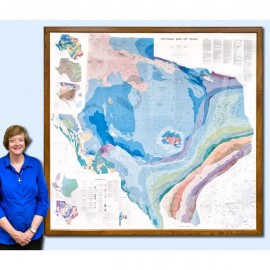
Plate VII, the geology of Austin map, is available in paper format as RX0001 and/or as a (43 MB) downloadable PDF as RX0001D.
Excerpted from the Introduction
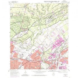
The area described in this report comprises 712 square miles centered on the City of Austin. The area extends north almost to Round Rock, south to the vicinity of Buda, east to just beyond Manor, and west to about 5 miles west of Oak Hill. It includes approximately 604 square miles of Travis County, 38 square miles of Hays County, 18 square miles of Bastrop County, and 52 square miles of Williamson County.
The aim of this publication is to supply geologic information that can be used to prevent or minimize problems that arise during urban development. A series of maps has been constructed for this purpose; the maps illustrate distribution of topographic conditions, soils, surface drainage, physical properties, rock types, land use, and vegetation.
Base maps were compiled from 7.5- and 15-minute U. S. Geological Survey topographic maps and a 1970 edition of a map of the City of Austin. Basic geologic mapping was completed on aerial photographs at a scale of 1:20,000. Supplementary maps were prepared by combining data from the basic geologic map with soils, engineering, topographic, and vegetation data. Final maps were constructed at scales of 1:62,500 (approximately 1 inch equals 1 mile) and 1:125,000 (approximately 1 inch equals 2 miles).
Keywords: Austin area, environmental geology, maps, mapping, Bastrop County, Williamson County, Texas, urban geology, urban planning
Citation
Garner, L. E., and Young, K. P., 1976, Environmental Geology of the Austin Area: An Aid to Urban Planning: The University of Texas at Austin, Bureau of Economic Geology, Report of Investigations No. 86, 39 p.