Miscellaneous Maps, Charts & Sections
-
Books & Reports
- Reports of Investigations
- Guidebooks
- Udden Series
- Geological Circulars
- Down To Earth
- Atlases of Major Oil and Gas Reservoirs
- Texas Memorial Museum Publications
- Environmental Geologic Atlas of the Texas Coastal Zone
- Mineral Resource Circulars
- Other Reports
- Seminars and Workshops
- Handbooks
- Submerged Lands of Texas
- Symposia
- Annual Reports
- Open File Reports
-
Maps & Cross Sections
- Thematic Maps
- Miscellaneous Maps, Charts & Sections
- Geologic Atlas of Texas
- STATEMAP Project Maps
- Geologic Quadrangle Maps
- Cross Sections
- Highway Geology Map
- Energy and Mineral Resource Maps
- Shoreline Change and Other Posters
- Wilcox Group, East Texas, Geological / Hydrological Folios
- Bouguer Gravity Atlas of Texas
- River Basin Regional Studies
- Featured Maps
- Posters
- Teachers & the Public
-
Geological Society Publications
- Gulf Coast Association of Geological Societies
- Alabama Geological Society
- Austin Geological Society
- Corpus Christi Geological Society
- Houston Geological Society
- Lafayette Geological Society
- Mississippi Geological Society
- New Orleans Geological Society
- South Texas Geological Society
- GCS SEPM Publications
- Historic BEG & UT Series


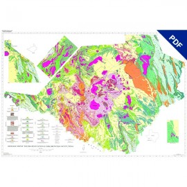
Geologic Maps of the Upper Cretaceous and Tertiary Strata, Big Bend National Park. Digital Download
MM0050D
For a print version: MM0050.
MM0050D. Geologic Maps of the Upper Cretaceous and Tertiary Strata, Big Bend National Park, Texas. R. W. Cooper, Coordinator. Five oversize color map sheets and one cross section sheet (scale 1:24,000), 2011. Downloadable PDF.
Keywords: cross sections, maps, geologic maps, Aguja Formation, Boquillas Formation, Buda Formation, Black Peaks Formation, Dagger Flat quadrangle, Bone Spring quadrangle, Javelina Formation, Pen Formation, McKinney Springs quadrangle, Rio Grande Village quadrangle, Roys Peak quadrangle, San Vicente quadrangle, Solis quadrangle, Cretaceous, Tertiary, Big Bend National Park, parks, national parks, Texas, West Texas
CONTENTS (not available separately)
Sheet 1. Geology of the Boquillas Formation and Related Cretaceous Rocks in the Dagger Flat and Bone Spring Quadrangles, Big Bend National Park, Texas, by Roger W. Cooper, Dee Ann Cooper, James B. Stevens, and Margaret S. Stevens
Sheet 2. Geology of the McKinney Springs Quadrangle, Big Bend National Park, Texas by Roger W. Cooper, Thomas M. Lehman, James B. Stevens, Margaret S. Stevens, and Dee Ann Cooper
Sheet 3. Geology of the Roys Peak Quadrangle, Big Bend National Park, Texas by Roger W. Cooper, James B. Stevens, Margaret S. Stevens, Dee Ann Cooper, and Thomas M. Lehman
Sheet 4. Geology of the San Vicente Quadrangle and Part of the Rio Grande Village Quadrangle, Big Bend National Park, Texas, by Thomas M. Lehman, Roger W. Cooper, James B. Stevens, Margaret S. Stevens, and Dee Ann Cooper
Sheet 5. Geology of the Solis Quadrangle, Big Bend National Park, Texas, by Thomas M. Lehman, Roger W. Cooper, James B. Stevens, Margaret S. Stevens, and Dee Ann Cooper
Sheet 6. Cross Sections of Big Bend National Park, Texas, by Roger W. Cooper and Dee Ann Cooper
Citation
Cooper, R. W., Coordinator, 2011, Geologic Maps of the Upper Cretaceous and Tertiary Strata, Big Bend National Park, Texas: The University of Texas at Austin, Bureau of Economic Geology, Miscellaneous Map No. 50, 5 maps, scale 1:24,000., and 1 cross section.