Miscellaneous Maps, Charts & Sections
-
Books & Reports
- Reports of Investigations
- Guidebooks
- Udden Series
- Geological Circulars
- Down To Earth
- Atlases of Major Oil and Gas Reservoirs
- Texas Memorial Museum Publications
- Environmental Geologic Atlas of the Texas Coastal Zone
- Mineral Resource Circulars
- Other Reports
- Seminars and Workshops
- Handbooks
- Submerged Lands of Texas
- Symposia
- Annual Reports
- Open File Reports
-
Maps & Cross Sections
- Thematic Maps
- Miscellaneous Maps, Charts & Sections
- Geologic Atlas of Texas
- STATEMAP Project Maps
- Geologic Quadrangle Maps
- Cross Sections
- Highway Geology Map
- Energy and Mineral Resource Maps
- Shoreline Change and Other Posters
- Wilcox Group, East Texas, Geological / Hydrological Folios
- Bouguer Gravity Atlas of Texas
- River Basin Regional Studies
- Featured Maps
- Posters
- Teachers & the Public
-
Geological Society Publications
- Gulf Coast Association of Geological Societies
- Alabama Geological Society
- Austin Geological Society
- Corpus Christi Geological Society
- Houston Geological Society
- Lafayette Geological Society
- Mississippi Geological Society
- New Orleans Geological Society
- South Texas Geological Society
- GCS SEPM Publications
- Historic BEG & UT Series


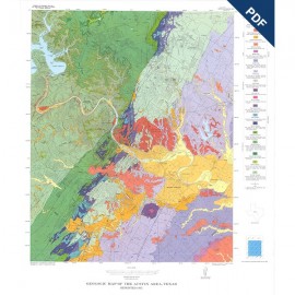
MM0053D. Geology of the Lower Lake Travis and Lake Austin Vicinity, Texas, by C. M. Woodruff, Jr., and E. W. Collins. Oversize color map on a topographic base, map scale 1:50,000, and accompanying 13-page text booklet. Downloadable PDF.
To purchase this publication in paper format, please order MM0053.
About This Publication
This map encompasses major impoundments of the Colorado River and includes the western urban edges of Austin and extensive suburban areas interspersed with undeveloped land. The map area is underlain by Cretaceous bedrock units that are displaced by normal faults composing the Balcones Fault Zone. Local Quaternary alluvial deposits cover bedrock at various topographic levels. The Balcones Escarpment extends across the southeastern corner of the map area and separates complex faulted terrain to the east from the Hill Country and dissected remnants of the Edwards Plateau to the west. In addition to showing surface-water resources provided by the lakes, the map area also depicts important groundwater resources, including Barton Springs and part of the recharge zone and upstream contributing watersheds that feed the springs. North of the Colorado River, extensive plateau uplands recharge the northern Edwards aquifer. In summary, this map presents geologic information pertinent to engineering, environmental, and resource issues related to rapid population growth west of Austin.
Keywords: Austin area, geologic maps, maps, Lake Austin, Lake Travis, Texas
Citation
Woodruff, C. M., Jr., and Collins, E. W., 2019, Geology of the Lower Lake Travis and Lake Austin Vicinity, Texas: The University of Texas at Austin, Bureau of Economic Geology, Miscellaneous Map No. 53, map scale 1:50,000, and accompanying text booklet.