Miscellaneous Maps, Charts & Sections
-
Books & Reports
- Reports of Investigations
- Guidebooks
- Udden Series
- Geological Circulars
- Down To Earth
- Atlases of Major Oil and Gas Reservoirs
- Texas Memorial Museum Publications
- Environmental Geologic Atlas of the Texas Coastal Zone
- Mineral Resource Circulars
- Other Reports
- Seminars and Workshops
- Handbooks
- Submerged Lands of Texas
- Symposia
- Annual Reports
- Open File Reports
-
Maps & Cross Sections
- Thematic Maps
- Miscellaneous Maps, Charts & Sections
- Geologic Atlas of Texas
- STATEMAP Project Maps
- Geologic Quadrangle Maps
- Cross Sections
- Highway Geology Map
- Energy and Mineral Resource Maps
- Shoreline Change and Other Posters
- Wilcox Group, East Texas, Geological / Hydrological Folios
- Bouguer Gravity Atlas of Texas
- River Basin Regional Studies
- Featured Maps
- Posters
- Teachers & the Public
-
Geological Society Publications
- Gulf Coast Association of Geological Societies
- Alabama Geological Society
- Austin Geological Society
- Corpus Christi Geological Society
- Houston Geological Society
- Lafayette Geological Society
- Mississippi Geological Society
- New Orleans Geological Society
- South Texas Geological Society
- GCS SEPM Publications
- Historic BEG & UT Series


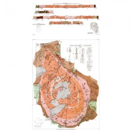
MM0046. Geologic Map of the Glenn Spring Quadrangle, Big Bend National Park, Texas, by E. W. Collins, W. R. Muehlberger, and P. W. Dickerson. Oversize, 2-sheet color map, scale 1:24,000, 2008.
To purchase this publication as a downloadable PDF, please order MM0046D.
About This Publication
Most of the area depicted on this map lies in desert and piedmont east of the Chisos Mountains. The area has a long and complex history, involving numerous geologic events. This map set is based on field and aerial-photographic interpretations and by studies and draft maps provided by many experts in the field. Funding for the study was provided by the National Park Service and the Bureau of Economic Geology.
Keywords: maps, geologic maps, Glenn Spring area, Big Bend National Park, parks, national parks, Texas
Citation
Collins, E. W., Muehlberger, W. R., and Dickerson, P. W., 2008, Geologic Map of the Glenn Spring Quadrangle, Big Bend National Park, Texas: The University of Texas at Austin, Bureau of Economic Geology, Miscellaneous Map No. 46, scale 1:24,000.