Index Series
-
Books & Reports
- Reports of Investigations
- Guidebooks
- Udden Series
- Geological Circulars
- Down To Earth
- Atlases of Major Oil and Gas Reservoirs
- Texas Memorial Museum Publications
- Environmental Geologic Atlas of the Texas Coastal Zone
- Mineral Resource Circulars
- Other Reports
- Seminars and Workshops
- Handbooks
- Submerged Lands of Texas
- Symposia
- Annual Reports
- Open File Reports
-
Maps & Cross Sections
- Thematic Maps
- Miscellaneous Maps, Charts & Sections
- Geologic Atlas of Texas
- STATEMAP Project Maps
- Geologic Quadrangle Maps
- Cross Sections
- Highway Geology Map
- Energy and Mineral Resource Maps
- Shoreline Change and Other Posters
- Wilcox Group, East Texas, Geological / Hydrological Folios
- Bouguer Gravity Atlas of Texas
- River Basin Regional Studies
- Featured Maps
- Posters
- Teachers & the Public
-
Geological Society Publications
- Gulf Coast Association of Geological Societies
- Alabama Geological Society
- Austin Geological Society
- Corpus Christi Geological Society
- Houston Geological Society
- Lafayette Geological Society
- Mississippi Geological Society
- New Orleans Geological Society
- South Texas Geological Society
- GCS SEPM Publications
- Historic BEG & UT Series


Index to Areal Geologic Maps in Texas, 1891-1961. Digital Download zip
IS0001D
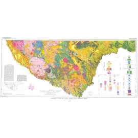
Index to Areal Geologic Maps in Texas, 1891-1961, by T. E. Brown. 20-p. booklet, 1 oversize color map, scale 1:1,200,000 (1 inch equals about 19 miles), 1963. Downloadable zip file containing the oversize map and page-size booklet. Digital Version.
IS0001D. Index to Areal Geologic Maps in Texas, 1891-1961, by T. E. Brown. 20-p. booklet, 1 oversize color map, scale 1:1,200,000 (1 inch equals about 19 miles), 1963. Downloadable zip file containing the oversize map and page-size booklet.
This color map outlines the areas of Texas in which geologic maps were made, from 1891 to 1961. The text booklet is a bibliography that lists the authors and publishers of those historic maps.
Keywords: maps, geologic maps, historic maps, Texas
Citation
Brown, T. E., 1963, Index to Areal Geologic Maps in Texas, 1891-1961: University of Texas, Austin, Bureau of Economic Geology, Index Series Map IS0001, scale 1:1,200,000.