Geologic Atlas of Texas
-
Books & Reports
- Reports of Investigations
- Guidebooks
- Udden Series
- Geological Circulars
- Down To Earth
- Atlases of Major Oil and Gas Reservoirs
- Texas Memorial Museum Publications
- Environmental Geologic Atlas of the Texas Coastal Zone
- Mineral Resource Circulars
- Other Reports
- Seminars and Workshops
- Handbooks
- Submerged Lands of Texas
- Symposia
- Annual Reports
- Open File Reports
-
Maps & Cross Sections
- Thematic Maps
- Miscellaneous Maps, Charts & Sections
- Geologic Atlas of Texas
- STATEMAP Project Maps
- Geologic Quadrangle Maps
- Cross Sections
- Highway Geology Map
- Energy and Mineral Resource Maps
- Shoreline Change and Other Posters
- Wilcox Group, East Texas, Geological / Hydrological Folios
- Bouguer Gravity Atlas of Texas
- River Basin Regional Studies
- Featured Maps
- Posters
- Teachers & the Public
-
Geological Society Publications
- Gulf Coast Association of Geological Societies
- Alabama Geological Society
- Austin Geological Society
- Corpus Christi Geological Society
- Houston Geological Society
- Lafayette Geological Society
- Mississippi Geological Society
- New Orleans Geological Society
- South Texas Geological Society
- GCS SEPM Publications
- Historic BEG & UT Series


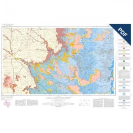
Emory Peak-Presidio Sheet. Digital Download
GA0015D
Geologic Atlas of Texas, Emory Peak-Presidio Sheet, by J. B. Brown, N. J. Cepeda, and F. W. Daugherty. Color map, scale 1:250,000, and 14-page explanatory booklet, 1979. For digital GIS files, order: GADQSW-D. Digital Version.
For a print version: GA0015.
Part of the Geologic Atlas of Texas, the Emory Peak-Presidio Sheet is an oversize color map that depicts the surface geology of parts of Presidio, Brewster, and Terrell Counties, Texas. The 14-page booklet indicates geologic formations, abbreviations, and ages.
Citation:
Brown, J. B., Cepeda, N. J., and Daugherty, T. W., 1979, Geologic Atlas of Texas, Emory Peak-Presidio Sheet: The University of Texas at Austin, Bureau of Economic Geology, Geologic Atlas of Texas, map scale 1:250,000.