Geologic Quadrangle Maps
-
Books & Reports
- Reports of Investigations
- Guidebooks
- Udden Series
- Geological Circulars
- Down To Earth
- Atlases of Major Oil and Gas Reservoirs
- Texas Memorial Museum Publications
- Environmental Geologic Atlas of the Texas Coastal Zone
- Mineral Resource Circulars
- Other Reports
- Seminars and Workshops
- Handbooks
- Submerged Lands of Texas
- Symposia
- Annual Reports
- Open File Reports
-
Maps & Cross Sections
- Thematic Maps
- Miscellaneous Maps, Charts & Sections
- Geologic Atlas of Texas
- STATEMAP Project Maps
- Geologic Quadrangle Maps
- Cross Sections
- Highway Geology Map
- Energy and Mineral Resource Maps
- Shoreline Change and Other Posters
- Wilcox Group, East Texas, Geological / Hydrological Folios
- Bouguer Gravity Atlas of Texas
- River Basin Regional Studies
- Featured Maps
- Posters
- Teachers & the Public
-
Geological Society Publications
- Gulf Coast Association of Geological Societies
- Alabama Geological Society
- Austin Geological Society
- Corpus Christi Geological Society
- Houston Geological Society
- Lafayette Geological Society
- Mississippi Geological Society
- New Orleans Geological Society
- South Texas Geological Society
- GCS SEPM Publications
- Historic BEG & UT Series


Igneous Geology of the Central Davis Mountains, Jeff Davis County, Texas. Digital Download
GQ0036D
A free, digital version of this publication can be found on: Texas ScholarWorks
To purchase a print version (if available): GQ0036
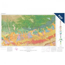
GQ0036D. Igneous Geology of the Central Davis Mountains, Jeff Davis County, Texas, by J. E. Anderson, Jr. Oversize color geologic map, scale 1:62,500, with 18-p. text, 1968. Downloadable PDF.
About This Publication (from its 1968 publication announcement)
Text accompanying this geologic quadrangle map contains a detailed description of the geologic formations of the central Davis Mountains, located in Jeff Davis, Presidio, and Brewster counties in Trans-Pecos Texas; the report deals more specifically with about 240 square miles in the highest part of the range. The color map includes three structure sections.
Keywords: Brewster County, Davis Mountains, igneous geology, Jeff Davis County, geologic maps, Presidio County, Trans-Pecos Texas, Texas
Citation
Anderson, J. E., Jr., 1968, Igneous Geology of the Central Davis Mountains, Jeff Davis County, Texas: The University of Texas at Austin, Bureau of Economic Geology, Geologic Quadrangle Map No. 36, scale 1:62,500.