Geologic Atlas of Texas
-
Books & Reports
- Reports of Investigations
- Guidebooks
- Udden Series
- Geological Circulars
- Down To Earth
- Atlases of Major Oil and Gas Reservoirs
- Texas Memorial Museum Publications
- Environmental Geologic Atlas of the Texas Coastal Zone
- Mineral Resource Circulars
- Other Reports
- Seminars and Workshops
- Handbooks
- Submerged Lands of Texas
- Symposia
- Annual Reports
- Open File Reports
-
Maps & Cross Sections
- Thematic Maps
- Miscellaneous Maps, Charts & Sections
- Geologic Atlas of Texas
- STATEMAP Project Maps
- Geologic Quadrangle Maps
- Cross Sections
- Highway Geology Map
- Energy and Mineral Resource Maps
- Shoreline Change and Other Posters
- Wilcox Group, East Texas, Geological / Hydrological Folios
- Bouguer Gravity Atlas of Texas
- River Basin Regional Studies
- Featured Maps
- Posters
- Teachers & the Public
-
Geological Society Publications
- Gulf Coast Association of Geological Societies
- Alabama Geological Society
- Austin Geological Society
- Corpus Christi Geological Society
- Houston Geological Society
- Lafayette Geological Society
- Mississippi Geological Society
- New Orleans Geological Society
- South Texas Geological Society
- GCS SEPM Publications
- Historic BEG & UT Series


Beaumont Sheet. Digital Download
GA0004D
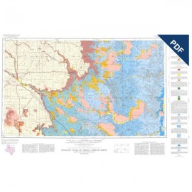
Geologic map of Texas, Beaumont Sheet, by C. A. Shelby, M. K. Pieper, S. Aronow, W. L. Fisher, J. H. McGowen, and V. E. Barnes. Color map, scale 1:250,000 and 4-page explanatory booklet, 1968; revised 1992. For GIS files, please order GADQSE-D. Digital Version.
For a print version: GA0004.
Part of the Geologic Atlas of Texas, the Beaumont Sheet is an oversize color map that depicts the surface geology of Montgomery, San Jacinto, and Hardin Counties and parts of Madison, Trinity, Polk, Tyler, Jasper, Newton, Orange, Jefferson, Liberty, Harris, Waller, Grimes, Walker, and Robertson Counties. The 4-page booklet indicates geologic formations, abbreviations, and ages.
This Sheet is a memorial to the late Harold Norman Fisk, distinguished geologist who was associated with Humble Oil & Refining Company at the time of his death in 1964. Dr. Fisk, a specialist in Pleistocene and Recent geology of the southern United States, identified and named the Montgomery and Bentley Formations which are mapped on the Beaumont and Houston Sheets.
Citation:
Shelby, C. A., Pieper, M. K., Aronow, S., Fisher, W. L., McGowen, J. H., and Barnes, V. E., 1992, Geologic Atlas of Texas, Beaumont Sheet: The University of Texas at Austin, Bureau of Economic Geology, Geologic Atlas Sheet, map scale 1:250,000.