Publication Search

Publications in Travis

Title Publication Year Sort ascending Abstract Author Series Publisher
Thumbnail of OFM0273 Geologic map of the Montopolis quadrangle, Travis County, Texas 2023

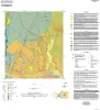
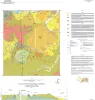
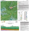
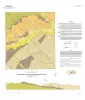
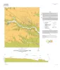
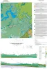
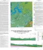
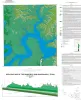
This map presents a graphic means for engineers, planners, and property owners to recognize and cope with the changes in substrate properties across this fault zone. Fault displacement has created a profound and abrupt change in land-use capabilities in this area.

Woodruff, C.M., Jr., Morris, J.N. Open-File Map Bureau of Economic Geology
Geologic Map of the Creedmoor Quadrangle, Texas Geologic Map of the Creedmoor Quadrangle, Texas 2022 Woodruff, C.M., Jr., Costard, L. Open-File Map Bureau of Economic Geology
Geologic map of the Lytton Springs quadrangle, Texas Geologic map of the Lytton Springs quadrangle, Texas 2021 Woodruff, C.M., Jr., Costard, L. Open-File Map Bureau of Economic Geology
Geologic map of the Taylor quadrangle Geologic map of the Taylor quadrangle 2020 Woodruff, C.M., Jr., Costard, L. Open-File Map Bureau of Economic Geology
Geologic map of the lower Lake Travis and Lake Austin vicinity, Texas Geologic map of the lower Lake Travis and Lake Austin vicinity, Texas 2019 Woodruff, C.M., Jr., Collins, E.W. Miscellaneous Map Bureau of Economic Geology
Geologic map of Mansfield Dam, Jollyville, Austin West, and Bee Cave quadrangles, Central Texas (Lower Lake Travis and Lake Austin vicinity) Geologic map of Mansfield Dam, Jollyville, Austin West, and Bee Cave quadrangles, Central Texas (Lower Lake Travis and Lake Austin vicinity) 2018 Woodruff, C.M., Jr., Collins, E.W. Open-File Map Bureau of Economic Geology
Geologic Map of the Mansfield Dam Quadrangle, Texas Geologic Map of the Mansfield Dam Quadrangle, Texas 2017 Woodruff, C.M., Jr. Open-File Map Bureau of Economic Geology
Geologic Map of the Shingle Hills-Dripping Springs-Driftwood-Rough Hollow-Henly-Hammetts Crossing Area, Central Texas Geologic Map of the Shingle Hills-Dripping Springs-Driftwood-Rough Hollow-Henly-Hammetts Crossing Area, Central Texas 2017 Collins, E.W. Open-File Map Bureau of Economic Geology
Geologic map of the upper Lake Travis area, Texas Geologic map of the upper Lake Travis area, Texas 2016 Woodruff, C.M., Jr., Collins, E.W. Miscellaneous Map Bureau of Economic Geology
Geologic map of the Bee Cave quadrangle, Texas Geologic map of the Bee Cave quadrangle, Texas 2016 Collins, E.W. Open-File Map Bureau of Economic Geology