Publications in Burnet
| Title | Publication Year Sort ascending | Abstract | Author | Series | Publisher | |
|---|---|---|---|---|---|---|
|
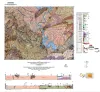
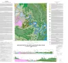
Geologic Map of the Gorman Falls Quadrangle, San Saba, Lampasas and Burnet Counties, Texas | 2025 | Hunt, B.B., Helper, M.A. | Open-File Map | Bureau of Economic Geology | |
|
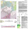
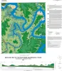
Geologic map of a Portion of the Southeastern Llano Uplift, Burnet, Llano, and Blanco Counties Texas | 2023 | Helper, M.A., Hunt, B.B., Barnes, V.E. | Open-File Map | Bureau of Economic Geology | |
|
Factors Influencing Rock Strength and Fluid Flow at the Basement–Sediment Interface from Field and Core-Based Observations, Llano Uplift, Texas | 2023 | The hydromechanical properties of the uppermost basement and of the basement–sediment interface influence multiple geologic processes of societal relevance, including the flow of groundwater; the accumulation of hydrocarbons, economic minerals, and geothermal resources; and the response of seismo |
Callahan, O.A., Eichhubl, Peter, Kyle, J.R. | Report of Investigations | Bureau of Economic Geology |
|
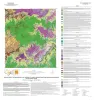
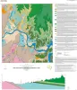
Geologic map of the Pedernales Falls, Johnson City, Howell Mountain, and Round Mountain quadrangles, Blanco County, Texas | 2021 | Hunt, B.B., Woodruff, C.M., Jr., Barnes, V.E. | Open-File Map | Bureau of Economic Geology | |
|
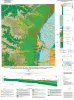
Geologic map of the upper Lake Travis area, Texas | 2016 | Woodruff, C.M., Jr., Collins, E.W. | Miscellaneous Map | Bureau of Economic Geology | |
|
Geologic map of the Pace Bend quadrangle, Texas | 2015 | Woodruff, C.M., Jr., Collins, E.W. | Open-File Map | Bureau of Economic Geology | |
|
Geologic map of the Smithwick quadrangle, Texas | 2014 | Woodruff, C.M., Jr. | Open-File Map | Bureau of Economic Geology | |
|
Geologic map of the west half of the Taylor, Texas, 30 X 60 minute quadrangle: central Texas urban corridor, encompassing Round Rock, Georgetown, Salado, Briggs, Liberty Hill, and Leander | 2005 | Collins, E.W. | Miscellaneous Map | Bureau of Economic Geology | |
|
Petrography and diagenesis of a half-billion-year-old cratonic sandstone (Hickory), Llano region, Texas | 2002 | We studied the Hickory Sandstone Member of the Riley Formation, Central Texas, to assess the diagenetic history of a cratonic sandstone, which, in spite of its great age, remains porous and permeable where it has not been buried more than 1 km. |
McBride, E.F., Abdel-Wahab, A.A., Milliken, K.L. | Report of Investigations | Bureau of Economic Geology |
|
Pavement Deflection and Seismic Refraction for Determining Bedrock Type, Depth, and Physical Properties beneath Roads | 2000 | We examined the relationship between three data types--geologic maps, measurements of pavement deflection under load, and seismic refraction data-- from diverse geologic settings in Texas to determine (1) whether geologic maps and seismic refraction data might be used to interpret deflections and |
Paine, J.G., Murphy, M.R. | Report of Investigations | Bureau of Economic Geology |