Publications in Burnet
| Title | Publication Year Sort ascending | Abstract | Author | Series | Publisher | |
|---|---|---|---|---|---|---|
|
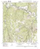
Geologic map of the Mahomet Quadrangle, Texas | 1999 | Collins, E.W. | Open-File Map | Bureau of Economic Geology | |
|
Geologic map of the Liberty Hill Quadrangle, Texas | 1999 | Collins, E.W. | Open-File Map | Bureau of Economic Geology | |
|
Geologic map of the Briggs quadrangle, Texas | 1999 | Collins, E.W. | Open-File Map | Bureau of Economic Geology | |
|
Geologic map of the Florence quadrangle, Texas | 1998 | Collins, E.W. | Open-File Map | Bureau of Economic Geology | |
|
Geologic map of the Ding Dong Quadrangle, Texas | 1998 | Collins, E.W. | Open-File Map | Bureau of Economic Geology | |
|
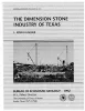
The dimension stone industry of Texas | 1992 | Garner, L.E. | Mineral Resource Circular | Bureau of Economic Geology | |
|
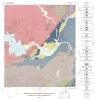
Geology of the Marble Falls quadrangle, Burnet and Llano Counties, Texas. | 1982 | Barnes, V.E. | Geologic Quadrangle Map | Bureau of Economic Geology | |
|
Geology of the Spicewood Quadrangle, Blanco, Burnet, and Travis Counties, Texas | 1982 | Barnes, V.E. | Geologic Quadrangle Map | Bureau of Economic Geology | |

|
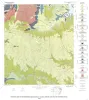
Geologic Atlas of Texas, Llano sheet | 1981 | Geologic map that depicts the surface geology of Mason, Llano, and Gillespie Counties and parts of Menard, Kimble, San Saba, McCulloch, Edwards, Real, Kerr, Kendall, Blanco, Hays, Travis, Williamson, and Burnet Counties, Texas. |
Barnes, V.E., Shell Oil Co., Boyer, R.E., Clabaugh, S.E., Baker, E.T. | Geologic Atlas of Texas | Bureau of Economic Geology |
|
Precambrian rocks of the southeastern Llano region, Texas | 1979 | Precambrian sedimentary rocks and associated mafic and silicic igneous rocks in Central Texas underwent a single episode of regional metamorphism about 1,050 million years (m.y.) ago. |
McGehee, R.V. | Geological Circular | Bureau of Economic Geology |