Publications in Burnet
| Title | Publication Year Sort ascending | Abstract | Author | Series | Publisher | |
|---|---|---|---|---|---|---|
|
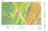
Geologic Atlas of Texas, Waco sheet | 1970 | Geologic maps that depicts the surface geology of McLennan, Limestone, and Falls Counties and parts of Bosque, Hill, Navarro, Freestone, Leon, Madison, Robertson, Milam, Bell, Lampasas, Coryell, and Hamilton Counties, Texas. |
Barnes, V.E., Humble Oil and Refining Co., Shell Oil Co., Mobil Oil Co., Proctor, C.V., Jr., McGowen, J.H., Haenggi, W.T., Hayward, O.T. | Geologic Atlas of Texas | Bureau of Economic Geology |

|
Trilobites of the Upper Cambrian Ptychaspid biomere, Wilberns Formation, central Texas | 1970 | Trilobites collected during the past 20 years from the Morgan Creek, Point Peak, and San Saba Members of the Wilberns Formation comprise 89 species assigned to 45 genera belonging to zones of the upper Franconian and Trempealeauan Stages of the Upper Cambrian Croixan Series. |
Longacre, S.A. | Report of Investigations | Bureau of Economic Geology |
|
Pre-Chappel conodonts of the Llano region, Texas | 1970 | This work was begun in 1964 and substantially completed in 1965; at that time conodont zones had been established in North America only for the Upper Devonian, by Clark and Becker (1960) for the Great Basin and Collinson, Scott, and Rexroad (1962) for the mid-continent. |
Seddon, George | Report of Investigations | Bureau of Economic Geology |

|
Nomenclature revision of basal Cretaceous rocks between the Colorado and Red Rivers, Texas | 1966 | Based on need for convenient, small-scale cartographic units, the basal Cretaceous rocks in Texas from Red River to Burnet County and on the Callahan Divide are herein divided into three distinctive lithologic sequences. |
Fisher, W.L., Rodda, P.U. | Report of Investigations | Bureau of Economic Geology |
|
Stratigraphy of the Fredericksburg Division, south-central Texas | 1964 | Sediments of the Fredericksburg Division in south-central Texas were deposited on the slowly subsiding west flank of the Tyler basin. In this region there are three stratigraphically distinct areas. The southern area has a thick Edwards Limestone unit overlying a thin Walnut Formation. |
Moore, C.H. | Report of Investigations | Bureau of Economic Geology |
|
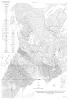
Geologic map of Southeastern Llano Uplift, Llano, Burnet, Blanco, and Gillespie counties, Texas | 1963 | McGehee, R.V. | Miscellaneous Map | Bureau of Economic Geology | |
|
The geologic story of Longhorn Cavern | 1963 | Guidebook | Bureau of Economic Geology | ||

|
Upper Franconian and Lower Trempealeauan Cambrian trilobites and brachiopods, Wilberns Formation, central Texas | 1962 | Forty-three species belonging to 28 genera, 12 species of brachipods belonging to 8 genera, and 1 species of gastropods are described from the Morgan Creek, Point Peak, and San Saba Members of the Wilberns Formation in the Llano Uplift. |
Bell, W.C., Ellinwood, H.L. | Report of Investigations | Bureau of Economic Geology |

|
Mineral resources of the Colorado River Industrial Development Association area | 1958 | The Colorado River Industrial Development Association area consists of ten counties [Bastrop, Blanco, Burnet, Colorado, Fayette, Llano, Matagorda, San Saba, Travis, and Wharton counties] in the lower watershed of Colorado River in Texas. |
Dietrich, J.W., Lonsdale, J.T. | Report of Investigations | Bureau of Economic Geology |

|
Field excursion, eastern Llano region | 1958 | The first entry in the Guidebook Series details a field excursion to the Eastern Llano Region of Central Texas in 1958. Retrace the footsteps of Virgil Barnes and the other state geologists in attendance: Stop 1. Honeycut Bend |
Barnes, V.E. | Guidebook | Bureau of Economic Geology |