Publications in Brewster
| Title | Publication Year Sort ascending | Abstract | Author | Series | Publisher | |
|---|---|---|---|---|---|---|

|
Electrical Imaging Catalog: Microresistivity Images and Core Photos from Fractured, Karsted, and Brecciated Carbonates | 1997 | Electrical images in boreholes are becoming increasingly important in interpreting the rock record. |
Hammes, Ursula | Geological Circular | Bureau of Economic Geology |
|
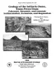
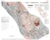
Geology of the Solitario dome, Trans-Pecos Texas: Paleozoic, Mesozoic, and Cenozoic sedimentation, tectonism, and magmatism | 1996 | The Solitario is a circular, 14- to 16-krn-diameter, mid-Tertiary laccolithic dome and caldera in southern Trans-Pecos Texas; it is among the world's largest laccoliths. |
Henry, C.D., Muehlberger, W.R., McCormick, C.L., Smith, C.I., Erdlac, R.J., Davis, L.L., Kunk, M.J. | Report of Investigations | Bureau of Economic Geology |
|
Stratigraphic analysis of the Upper Devonian Woodford Formation, Permian Basin, West Texas and southeastern New Mexico | 1991 | The Upper Devonian Woodford Formation is an organic-rich petroleum source rock that extends throughout West Texas and southeastern New Mexico and currently is generating oil or gas in the subsurface. |
Comer, J.B. | Report of Investigations | Bureau of Economic Geology |

|
Geology and Tertiary igneous activity of the Hen Egg Mountain and Christmas Mountains quadrangles, Big Bend region, Trans-Pecos Texas | 1989 | Cretaceous sedimentary rocks and Tertiary intrusive, extrusive, and volcaniclastic rocks dominate the geology of the Hen Egg Mountain and Christmas Mountains quadrangles in the Big Bend region of Texas. |
Henry, C.D., Price, J.G., Miser, D.E. | Report of Investigations | Bureau of Economic Geology |
|
Structural geology of Sierra del Carmen, Trans-Pecos Texas | 1988 | Moustafa, A.R. | Geologic Quadrangle Map | Bureau of Economic Geology | |
|
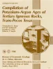
Compilation of potassium-argon ages of Tertiary igneous rocks, Trans-Pecos Texas | 1986 | This compilation of potassium-argon (K-Ar) ages of igneous rocks of the Tertiary volcanic field of Trans-Pecos Texas includes all published ages known to us as well as many unpublished results. |
Henry, C.D., McDowell, F.W., Price, J.G., Smyth, R.C. | Geological Circular | Bureau of Economic Geology |
|
Tectonic map of the Basin and Range Province of Texas and adjacent Mexico | 1985 | Henry, C.D., Price, J.G., Gluck, J.K., Bockoven, N.T. | Miscellaneous Map | Bureau of Economic Geology | |
|
Annotated bibliography of mineral deposits in Trans-Pecos Texas | 1983 | Price, J.G., Henry, C.D., Standen, A.R. | Mineral Resource Circular | Bureau of Economic Geology | |

|
Geologic Atlas of Texas, Fort Stockton sheet (revised 1994) | 1982 | Geologic map that depicts the surface geology of parts of Jeff Davis, Reeves, Pecos, Terrell, Brewster, and Presidio Counties, Texas. The 9-page booklet indicates geologic formations, abbreviations, and ages. |
Barnes, V.E., Humboldt Oil and Refining Co., Mobil Oil Co., Geophoto Services Inc., Cities Service Petroleum Co., Anderson, J.E., Brown, J.B., Gries, J.C. | Geologic Atlas of Texas | Bureau of Economic Geology |
|
Structure of the Presidio Bolson area, Texas, interpreted from gravity data | 1980 | Mraz, J.R., Keller, G.R. | Geological Circular | Bureau of Economic Geology |