Publications in Brewster
| Title | Publication Year Sort ascending | Abstract | Author | Series | Publisher | |
|---|---|---|---|---|---|---|

|
Geologic Map of the White Hills Quadrangle, Texas | 2016 | Elliott, Brent A. | Open-File Map | Bureau of Economic Geology | |
|
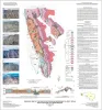
Geologic Maps of the Upper Cretaceous and Tertiary Strata, Big Bend National Park, Texas | 2011 | This six-sheet set of oversize colorful geologic maps and cross sections presents new interpretations on the outcrop pattern and complex structure within the Upper Cretaceous Del Rio, Buda, Boquillas, Pen, Aguja, Javelina, and Cretaceous-Tertiary Black Peaks Formations of Big Bend National Park. |
Cooper, R.W. | Miscellaneous Map | Bureau of Economic Geology |
|
Geologic map of Mariscal Mountain, Big Bend National Park, Texas | 2010 | Dickerson, P.W., Muehlberger, W.R., Collins, E.W. | Miscellaneous Map | Bureau of Economic Geology | |
|
Geologic map of the Southern Franklin Mountains, El Paso, Texas, with focus on collapse breccia | 2010 | Lucia, F.J. | Miscellaneous Map | Bureau of Economic Geology | |
|
Geologic map of the Chances Store quadrangle, Texas | 2007 | Collins, E.W. | Open-File Map | Bureau of Economic Geology | |
|
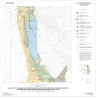
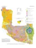
Down to earth at Big Bend Ranch State Park, Texas: geologic map and trail-side geology | 2002 | This full-color, oversize map, designed for hikers in the park, describes geologic units and features. The text documents the geologic history of the Big Bend Ranch State Park area. Support was provided by the Texas Parks and Wildlife Department and the U.S. Geological Survey. |
Henry, C.D., Raney, J.A. | Down To Earth | Bureau of Economic Geology |

|
Regional stratigraphic cross sections, Comanche Cretaceous (Fredericksburg - Washita Division), Edwards and Stockton plateaus, West Texas: interpretation of sedimentary facies, depositional cycles, and tectonics | 2000 | Six interlocking regional stratigraphic cross sections of Lower Cretaceous strata (middle Albian-lower Cenomanian) of the Edwards and Stockton Plateaus of West Texas illustrate the vertical and lateral extent of lithostratigraphic units and distribution of facies and facies tracts. |
Smith, C.I., Brown, J.B., Lozo, F.E. | Cross Sections | Bureau of Economic Geology |
|
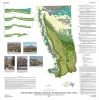
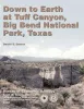
Down to earth at Tuff Canyon, Big Bend National Park, Texas | 2000 | Written for a nontechnical audience, this guide describes the Tuff Canyon area in detail and includes a glossary of terms that might be unfamiliar to non-geologists. Color photographs and sketches depict the geologic features, fauna, and flora of this part of Big Bend National Park. |
Barker, D.S. | Down To Earth | Bureau of Economic Geology |
|
Tertiary volcanism of the Boficillos Mountains and Big Bend Ranch State Park, Texas: revised stratigraphy and 40Ar/39Ar geochronology | 1998 | The Bofecillos Mountains and Big Bend Ranch State Park contain a complex sequence of volcanic, volcaniclastic, and intrusive rocks that erupted from sources both within and outside the area. |
Henry, C.D., Davis, L.L., Kunk, M.J., McIntosh, W.C. | Report of Investigations | Bureau of Economic Geology |
|
Geology of Big Bend Ranch State Park, Texas | 1998 | Big Bend Ranch State Park, the largest in the Texas State Parks System, lies in the rugged Big Bend country of West Texas (figs. 1 and 2). The primary attraction of Big Bend country is its scenery, and scenery is geology. |
Henry, C.D. | Guidebook | Bureau of Economic Geology |