Publications in Brewster
| Title | Publication Year Sort ascending | Abstract | Author | Series | Publisher | |
|---|---|---|---|---|---|---|
|
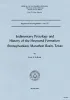
Sedimentary petrology and history of the Haymond Formation (Pennsylvanian), Marathon Basin, Texas | 1966 | This report treats the sedimentary petrology and history of the Haymond Formation, a monotonous sequence of interbedded sandstone and shale that has a maximum preserved thickness of 4,300 feet. |
McBride, E.F. | Report of Investigations | Bureau of Economic Geology |
|
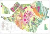
Geologic map of the Big Bend National Park, Brewster County, Texas | 1966 | Maxwell, R.A. | Miscellaneous Map | Bureau of Economic Geology | |
|
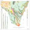
Geology of Black Gap Area, Brewster County, Texas | 1966 | The wedge-shaped Black Gap area in southern Brewsier County, Texas, occupies approximately 4,50 square miles east of the Big Bend National Park. |
St. John, D.E. | Geologic Quadrangle Map | Bureau of Economic Geology |
|
Graptolite Faunas of the Marathon Region, West Texas | 1960 | Berry, W.B.N. | UT Publication | ||
|
Aspects of the Geology of Texas: A Symposium | 1960 | Conselman, F.B., Martinez, J.D., Statham, E.H., Howell, L.G., Nelson, H.F., Nicholson, J.H., Wilson, J.L., Majewske, O.P. | UT Publication | ||
|
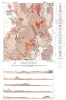
Cathedral Mountain quadrangle, Brewster County, Texas | 1955 | McAnulty, W.N. | Miscellaneous Map | Bureau of Economic Geology | |
|
Geology of Cathedral Mountain quadrangle, Brewster County, Texas | 1955 | Rocks exposed in the Cathedral Mountain quadrangle in the southeastern DavisMountains of Trans-Pecos Texas are assigned to the Word formation and to Capitan limestone in the Permian Guadalupe series; to the Maxon sandstone, Edwards limestone, Georgetown limestone, and Grayson (Del Rio) marl in th |
McAnulty, W.N. | Report of Investigations | Bureau of Economic Geology |
|
Geology of Hood Spring quadrangle, Brewster County, Texas | 1954 | The Hood Spring quadrangle, in the central part of Brewster County, Texas, contains a segment of the southeast rim of the Marathon basin. |
Graves, R.W. | Report of Investigations | Bureau of Economic Geology |
|
Geologic Map and Structure Sections of Hood Spring Quadrangle, Texas | 1954 | Graves, R.W. | Miscellaneous Map | Bureau of Economic Geology | |
|
Geology of the Agua Fria quadrangle, Brewster County, Texas | 1953 | The 15-minute Agua Fria quadrangle in southwestern Brewster County, Texas, is arid, sparsely vegetated, and includes diverse topographic features that result chiefly from complex structure and variation in rock resistance to erosion. |
Moon, C.G. | Report of Investigations | Bureau of Economic Geology |