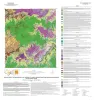
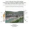
Publication Search

Publications in Blanco

Title Publication Year Sort ascending Abstract Author Series Publisher
Geologic map of a Portion of the Southeastern Llano Uplift, Burnet, Llano, and Blanco Counties Texas Geologic map of a Portion of the Southeastern Llano Uplift, Burnet, Llano, and Blanco Counties Texas 2023 Hunt, B.B., Barnes, V.E. Open-File Map Bureau of Economic Geology
Geologic map of the Pedernales Falls, Johnson City, Howell Mountain, and Round Mountain quadrangles, Blanco County, Texas Geologic map of the Pedernales Falls, Johnson City, Howell Mountain, and Round Mountain quadrangles, Blanco County, Texas 2021 Hunt, B.B., Woodruff, C.M., Jr., Barnes, V.E. Open-File Map Bureau of Economic Geology
Geologic map of the Pedernales Falls quadrangle, Blanco County, Texas Geologic map of the Pedernales Falls quadrangle, Blanco County, Texas 2019 Woodruff, C.M., Jr., Costard, L., Barnes, V.E. Open-File Map Bureau of Economic Geology
Geologic Map of the Shingle Hills-Dripping Springs-Driftwood-Rough Hollow-Henly-Hammetts Crossing Area, Central Texas Geologic Map of the Shingle Hills-Dripping Springs-Driftwood-Rough Hollow-Henly-Hammetts Crossing Area, Central Texas 2017 Collins, E.W. Open-File Map Bureau of Economic Geology
Geologic map of the upper Lake Travis area, Texas Geologic map of the upper Lake Travis area, Texas 2016 Woodruff, C.M., Jr., Collins, E.W. Miscellaneous Map Bureau of Economic Geology
AGS GB 33 Cover Surface to Subsurface Trinity Lithostratigraphy: Implications for Groundwater Availability in the Hill Country, Eastern Blanco and Northern Hays Counties, Texas 2011

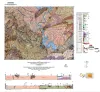
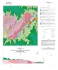
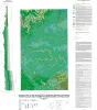
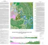
This field trip is a follow-up and complement to the publication of the Hydrogeologic Atlas of the Hill Country Trinity Aquifer, Blanco, Hays, and Travis Counties, Central Texas (referenced as Wierman et al., 2010 or “HA” throughout this guidebook).

Hunt, B.B., Wierman, D.A., Brown, A.S., Woodruff, C.M., Jr., Fielder, R.G. Austin Geological Society Austin Geological Society
Geologic map of the Henly quadrangle, Texas Geologic map of the Henly quadrangle, Texas 2002 Collins, E.W. Open-File Map Bureau of Economic Geology
Petrography and diagenesis of a half-billion-year-old cratonic sandstone (Hickory), Llano region, Texas Petrography and diagenesis of a half-billion-year-old cratonic sandstone (Hickory), Llano region, Texas 2002

We studied the Hickory Sandstone Member of the Riley Formation, Central Texas, to assess the diagenetic history of a cratonic sandstone, which, in spite of its great age, remains porous and permeable where it has not been buried more than 1 km.

McBride, E.F., Abdel-Wahab, A.A., Milliken, K.L. Report of Investigations Bureau of Economic Geology
Geologic map of the Crabapple Creek quadrangle, Texas Geologic map of the Crabapple Creek quadrangle, Texas 2002 Collins, E.W. Open-File Map Bureau of Economic Geology
Geologic map of the Payton quadrangle, Texas Geologic map of the Payton quadrangle, Texas 2002 Collins, E.W. Open-File Map Bureau of Economic Geology