Publications in Blanco
| Title | Publication Year Sort ascending | Abstract | Author | Series | Publisher | |
|---|---|---|---|---|---|---|
|
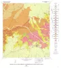
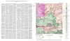
Geology of the Johnson City Quadrangle, Blanco County, Texas | 1963 | Barnes, V.E. | Geologic Quadrangle Map | Bureau of Economic Geology | |
|
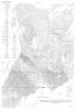
Geologic map of Southeastern Llano Uplift, Llano, Burnet, Blanco, and Gillespie counties, Texas | 1963 | McGehee, R.V. | Miscellaneous Map | Bureau of Economic Geology | |
|
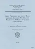
Upper Franconian and Lower Trempealeauan Cambrian trilobites and brachiopods, Wilberns Formation, central Texas | 1962 | Forty-three species belonging to 28 genera, 12 species of brachipods belonging to 8 genera, and 1 species of gastropods are described from the Morgan Creek, Point Peak, and San Saba Members of the Wilberns Formation in the Llano Uplift. |
Bell, W.C., Ellinwood, H.L. | Report of Investigations | Bureau of Economic Geology |
|
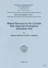
Mineral resources of the Colorado River Industrial Development Association area | 1958 | The Colorado River Industrial Development Association area consists of ten counties [Bastrop, Blanco, Burnet, Colorado, Fayette, Llano, Matagorda, San Saba, Travis, and Wharton counties] in the lower watershed of Colorado River in Texas. |
Dietrich, J.W., Lonsdale, J.T. | Report of Investigations | Bureau of Economic Geology |
|
Field excursion, eastern Llano region | 1958 | The first entry in the Guidebook Series details a field excursion to the Eastern Llano Region of Central Texas in 1958. Retrace the footsteps of Virgil Barnes and the other state geologists in attendance: Stop 1. Honeycut Bend |
Barnes, V.E. | Guidebook | Bureau of Economic Geology |
|
Devonian - Mississippian transition in central Texas | 1957 | The Devonian-Mississippian transition outcrops of central Texas are here described summarily and assigned to a new stratigraphic unit, the Houy Formation. The beds included are mainly Upper Devonian, but partly Lower Mississippian. Locally a basal fraction may be Middle Devonian. |
Cloud, P.E., Jr., Barnes, V.E., Hass, W.H. | Report of Investigations | Bureau of Economic Geology |
| |
Map showing correlation of geologic, gravity, and magnetic observations, Blanco and Gillespie Counties, Texas | 1955 | Barnes, V.E., Romberg, Frederick, Anderson, W.A. | Miscellaneous Map | Bureau of Economic Geology | |
|
The faunas of the Riley Formation in central Texas | 1954 | Sixty-eight species of trilobites, 10 species of inarticulate brachiopods, two species of articulate brachiopods, one ostracode and fragments of sponges, pelmatozoan echinoderms and unidentifiable organisms constitute the faunas of the Riley formation. |
Palmer, A.R. | Report of Investigations | Bureau of Economic Geology |
|
Geologic map of the North Grape Creek Quadrangle, Blanco and Gillespie County, Texas | 1952 | North Grape Creek quadrangle is south of the Llano region and is mostly in the broad Pedernales River basin. A few outliers of the Edwards Plateau are present in the western part of the quadrangle. |
Barnes, V.E. | Geologic Quadrangle Map | Bureau of Economic Geology |
|
Geologic Map of the Blowout Quadrangle, Blanco, Gillespie, and Llano Counties, Texas | 1952 | Barnes, V.E. | Geologic Quadrangle Map | Bureau of Economic Geology |