Publications in Blanco
| Title | Publication Year Sort ascending | Abstract | Author | Series | Publisher | |
|---|---|---|---|---|---|---|
|
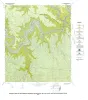
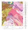
Geology of the Hammetts Crossing Quadrangle, Blanco, Hays, and Travis Counties, Texas | 1982 | Barnes, V.E. | Geologic Quadrangle Map | Bureau of Economic Geology | |
|
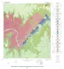
Geology of the Pedernales Falls quadrangle, Blanco County, Texas | 1982 | Barnes, V.E. | Geologic Quadrangle Map | Bureau of Economic Geology | |
|
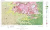
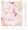
Geologic Atlas of Texas, Llano sheet | 1981 | Geologic map that depicts the surface geology of Mason, Llano, and Gillespie Counties and parts of Menard, Kimble, San Saba, McCulloch, Edwards, Real, Kerr, Kendall, Blanco, Hays, Travis, Williamson, and Burnet Counties, Texas. |
Barnes, V.E., Shell Oil Co., Boyer, R.E., Clabaugh, S.E., Baker, E.T. | Geologic Atlas of Texas | Bureau of Economic Geology |
|
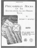
Precambrian rocks of the southeastern Llano region, Texas | 1979 | Precambrian sedimentary rocks and associated mafic and silicic igneous rocks in Central Texas underwent a single episode of regional metamorphism about 1,050 million years (m.y.) ago. |
McGehee, R.V. | Geological Circular | Bureau of Economic Geology |
|
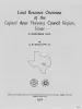
Land resource overview of the Capital Area Planning Council Region, Texas -- a nontechnical guide | 1979 | Bastrop, Blanco, Burnet, Caldwell, Fayette, Hays, Lee, Llano, Travis, and Williamson Counties make up the Capital Area Planning Council (CAPCO) region in Central Texas (fig. 1). The region covers 8,427 square miles (21,826 km2) and includes land of great physical diversity. |
Woodruff, C.M., Jr. | Selected Reports | Bureau of Economic Geology |
|
Geology of the Dunman Mountain Quadrangle, Llano, Burnet, and Blanco Counties, Texas | 1978 | Barnes, V.E. | Geologic Quadrangle Map | Bureau of Economic Geology | |
|
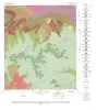
Geology of the Howell Mountain quadrangle, Blanco and Llano Counties, Texas | 1978 | Barnes, V.E. | Geologic Quadrangle Map | Bureau of Economic Geology | |
|
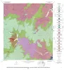
Geologic map of the Round Mountain quadrangle, Blanco, Burnet, and Llano counties. Texas | 1978 | Barnes, V.E. | Geologic Quadrangle Map | Bureau of Economic Geology | |
|
The Moore Hollow Group of central Texas | 1977 | Middle and Upper Cambrian rocks and locally up to 90 feet of Lower Ordovician rocks in Central Texas, are here named the Moore Hollow Group. |
Barnes, V.E., Bell, W.C. | Report of Investigations | |
|
Geology of the Click Quadrangle, Llano and Blanco Counties, Texas | 1977 | Barnes, V.E. | Geologic Quadrangle Map | Bureau of Economic Geology |