Publications in Blanco
| Title | Publication Year Sort ascending | Abstract | Author | Series | Publisher | |
|---|---|---|---|---|---|---|
|
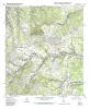
Geologic map of the Henly quadrangle, Texas | 2002 | Collins, E.W. | Open-File Map | Bureau of Economic Geology | |
|
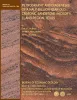
Petrography and diagenesis of a half-billion-year-old cratonic sandstone (Hickory), Llano region, Texas | 2002 | We studied the Hickory Sandstone Member of the Riley Formation, Central Texas, to assess the diagenetic history of a cratonic sandstone, which, in spite of its great age, remains porous and permeable where it has not been buried more than 1 km. |
McBride, E.F., Abdel-Wahab, A.A., Milliken, K.L. | Report of Investigations | Bureau of Economic Geology |
|
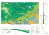
Geologic Map of the New Braunfels, Texas, 30x60 Minute Quadrangle | 2000 | Collins, E.W. | Miscellaneous Map | Bureau of Economic Geology | |
|
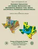
Pavement Deflection and Seismic Refraction for Determining Bedrock Type, Depth, and Physical Properties beneath Roads | 2000 | We examined the relationship between three data types--geologic maps, measurements of pavement deflection under load, and seismic refraction data-- from diverse geologic settings in Texas to determine (1) whether geologic maps and seismic refraction data might be used to interpret deflections and |
Paine, J.G., Murphy, M.R. | Report of Investigations | Bureau of Economic Geology |
|
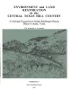
Environment and Restoration in the Central Texas Hill Country, A Geologic Excursion to Selah, Bamburger Ranch, Blanco County, Texas | 1997 | Woodruff, C.M., Jr. | Austin Geological Society | Austin Geological Society | |
|
Geologic map of the Spring Branch Quadrangle, Texas | 1992 | Collins, E.W. | Open-File Map | Bureau of Economic Geology | |
|
Geologic map of the Fischer quadrangle, Texas | 1992 | Collins, E.W. | Open-File Map | Bureau of Economic Geology | |
|
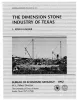
The dimension stone industry of Texas | 1992 | Garner, L.E. | Mineral Resource Circular | Bureau of Economic Geology | |
|
The Guadalupe - Lavaca - San Antonio - Nueces River basins regional study: San Antonio East - Llano East sheets | 1985 | Wermund, E.G., Gustavson, T.C., Garner, L.E., Morton, R.A., Woodruff, C.M., Jr., Macpherson, G.L., McKinney, L., Nilsson, J. | River Basins Regional Studies | Bureau of Economic Geology | |
|
Geology of the Pedernales Falls quadrangle, Blanco County, Texas | 1982 | Barnes, V.E. | Geologic Quadrangle Map | Bureau of Economic Geology |