
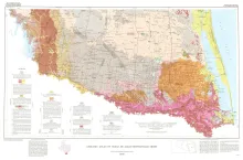
Geologic map that depicts surface geology of Starr, Hidalgo, Willacy, and Cameron Counties and parts of Zapata, Jim Hogg, Brooks, and Kenedy Counties.
The Bureau of Economic Geology has been conducting regional studies of the Frio Formation along the Texas Gulf Coast to evaluate potential geothermal energy from deep, geopressured sandstone reservoirs (Bebout, Dorfman, and Agagu, 1975; Bebout, Agagu, and Dorfman, 1975). The procedures used in this evaluation were reviewed at the Second Geopressured Geothermal Energy Conference held at The University of Texas at Austin and sponsored by the United States Energy Research and Development Administration. The index map (fig. 1) and cross sections (figs.
The Texas Coastal Zone is marked by diversity in geography, resources, climate, and industry. It is richly andowed with extensive petroleum reserves, sulfur and salt, deep-water ports, intracoastal waterways, mild climate, good water supplies, abundant wildlife, commercial fishing resources, unusual recreational potential, and large tracts of uncrowded land in close proximity to major population centers.