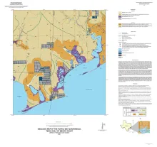
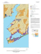
Home
Main navigation
  • Maps
    • Geologic Maps and Cross Sections
    • Thematic Maps
    • Other Maps
  • Reports
    • Reports of Investigation
    • Geological Circulars
    • Oil and Gas Atlases
    • Coastal Studies
    • Historic BEG Reports
    • Open-File Reports
    • Mineral Resources
    • Other Reports
  • Education and General Interest
    • Down to Earth
    • Udden Series
    • Guidebooks
    • K-12 Resources
    • Thematic Maps
  • Geological Society Publications
    • Austin Geological Society
    • Corpus Christi Geological Society
    • Gulf Coast Association of Geological Societies
    • Gulf Coast Section SEPM
    • Houston Geological Society
    • Lafayette Geological Society
    • Mississippi Geological Society
    • New Orleans Geological Society
    • South Texas Geological Society
    • Texas Memorial Museum
User account menu
  • Log in
Shopping cart 0 items

Publication Search

Advanced Search
Browse By Author
Browse By County
Browse By Keyword
Signup for news and announcements
Store logo

Latest Publications:

Upper Pennsylvanian and Lower Permian Shelf, Slope, and Basin Depositional Facies of the Southern Eastern Shelf of the Midland Basin: Core Workshop
Author
Hentz, T.F., Ambrose, W.A., Palacios, F.C., Baumgardner, R.W., Jr.
Keywords
Basin, Depositional Systems, Eastern Shelf, Midland Basin, Pennsylvanian, Permian, Shelf, Slope
Canyon Dam Spillway Gorge and Natural Bridge Caverns: Geologic Excursions in the Balcones Fault Zone, Central Texas
Author
Woodruff, C.M., Jr., Collins, E.W., Potter, E.C., Loucks, R.G.
Geologic Map of the Pontotoc Quadrangle, Texas
Author
Elliott, Brent A.
Keywords
Geologic Maps, Pontotoc Quadrangle
Geologic map of the Saint Charles Bay quadrangle, Texas Gulf of Mexico coast
Author
Paine, J.G., Collins, E.W.
Keywords
Geologic Maps, Gulf Of Mexico, Saint Charles Bay Quadrangle
Lithofacies of the Wolfcamp and Lower Leonard Intervals, Southern Midland Basin
Author
Baumgardner, R.W., Jr., Hamlin, H.S., Rowe, H.D.
Keywords
Leonard, Lithofacies, Midland Basin, Wolfcamp

Pagination

  • First page « First
  • Previous page ‹‹
  • …
  • Page 11
  • Page 12
  • Page 13
  • Page 14
  • Page 15
  • Page 16
  • Page 17
  • Page 18
  • Page 19
  • …
  • Next page ››
  • Last page Last »
Footer
  • About
  • Bureau Homepage

Email: pubsales@beg.utexas.edu

Phone (8am-5pm CST): 512-471-7144