Well Record Circulars
-
Books & Reports
- Reports of Investigations
- Guidebooks
- Udden Series
- Geological Circulars
- Down To Earth
- Atlases of Major Oil and Gas Reservoirs
- Texas Memorial Museum Publications
- Environmental Geologic Atlas of the Texas Coastal Zone
- Mineral Resource Circulars
- Other Reports
- Seminars and Workshops
- Handbooks
- Submerged Lands of Texas
- Symposia
- Annual Reports
- Open File Reports
-
Maps & Cross Sections
- Thematic Maps
- Miscellaneous Maps, Charts & Sections
- Geologic Atlas of Texas
- STATEMAP Project Maps
- Geologic Quadrangle Maps
- Cross Sections
- Highway Geology Map
- Energy and Mineral Resource Maps
- Shoreline Change and Other Posters
- Wilcox Group, East Texas, Geological / Hydrological Folios
- Bouguer Gravity Atlas of Texas
- River Basin Regional Studies
- Featured Maps
- Posters
- Teachers & the Public
-
Geological Society Publications
- Gulf Coast Association of Geological Societies
- Alabama Geological Society
- Austin Geological Society
- Corpus Christi Geological Society
- Houston Geological Society
- Lafayette Geological Society
- Mississippi Geological Society
- New Orleans Geological Society
- South Texas Geological Society
- GCS SEPM Publications
- Historic BEG & UT Series

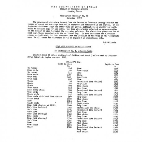
WR0028. Some Well Records in Falls County [Texas]. 3 p., 1929.
About the Well Record (WR) Series
[These] circulars issued from the Bureau of Economic Geology contain the record of cores and cuttings from well received and described in the Bureau. In some instances, driller's logs and other data are given, although it is usually impracticable to include logs of all wells, the logs given being selected as representative of the county or area to which the circular relates. The elevations given are for the most part those reported with the driller's log. In some instances the elevation given, as indicated, is that obtained from the location of the well on the topographic map. In all cases the elevation is to be regarded as approximate only.--- E. H. Sellards
About This Document
This circular consists of a driller's log of the De Graffenried No. 1, Johnson-Myrin well, located about 2.5. miles northeast of Chilton.
Keywords: driller's logs, Falls County, Texas
Citation
Bureau of Economic Geology, The University of Texas at Austin, Some Well Records in Falls County, Texas. WR0028, 3 p., 1929.
