STATEMAP Project Maps
-
Books & Reports
- Reports of Investigations
- Guidebooks
- Udden Series
- Geological Circulars
- Down To Earth
- Atlases of Major Oil and Gas Reservoirs
- Texas Memorial Museum Publications
- Environmental Geologic Atlas of the Texas Coastal Zone
- Mineral Resource Circulars
- Other Reports
- Seminars and Workshops
- Handbooks
- Submerged Lands of Texas
- Symposia
- Annual Reports
- Open File Reports
-
Maps & Cross Sections
- Thematic Maps
- Miscellaneous Maps, Charts & Sections
- Geologic Atlas of Texas
- STATEMAP Project Maps
- Geologic Quadrangle Maps
- Cross Sections
- Highway Geology Map
- Energy and Mineral Resource Maps
- Shoreline Change and Other Posters
- Wilcox Group, East Texas, Geological / Hydrological Folios
- Bouguer Gravity Atlas of Texas
- River Basin Regional Studies
- Featured Maps
- Posters
- Teachers & the Public
-
Geological Society Publications
- Gulf Coast Association of Geological Societies
- Alabama Geological Society
- Austin Geological Society
- Corpus Christi Geological Society
- Houston Geological Society
- Lafayette Geological Society
- Mississippi Geological Society
- New Orleans Geological Society
- South Texas Geological Society
- GCS SEPM Publications
- Historic BEG & UT Series


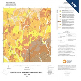
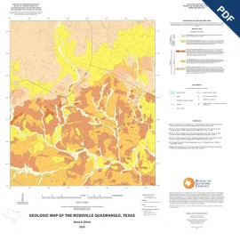
OFM0236D. Geologic Map of the Somerset Quadrangle, Texas, by B. A. Elliott. Downloadable PDF. Oversize geologic map on color topographic base, map scale 1:24,000, 2018. To purchase this publication in paper format, please order OFM0236.
About This Publication
This map, one of several 1:24,000-scale maps of the region south of San Antonio, Texas, focuses on sand resources in the Carrizo-Wilcox formations of south-central Texas. Maps of this region provide a basic geologic framework to aid in managing water and earth resources; planning land use; identifying aquifer recharge areas; and identifying earth resources such as dimension stone, aggregate, construction sand and specialty sand, and gravel. The map illustrates the geology of Quaternary and Tertiary deposits that overlie Cretaceous strata just south of San Antonio. The Eocene-age Carrizo Sand formation is an important mineral-industry resource in the region, and this and other similar geologic maps will assist in recognizing additional economic sand resources and the aquifer recharge zone, all of which are important for water resource management in the region.
Keywords: maps, geologic maps, Atascosa County, Bexar County, Somerset area, Texas
Citation
Elliott, B. A., 2018, Geologic Map of the Somerset Quadrangle, Texas: The University of Texas at Austin, Bureau of Economic Geology, Open-File Map No. 236, scale 1:24,000.