STATEMAP Project Maps
-
Books & Reports
- Reports of Investigations
- Guidebooks
- Udden Series
- Geological Circulars
- Down To Earth
- Atlases of Major Oil and Gas Reservoirs
- Texas Memorial Museum Publications
- Environmental Geologic Atlas of the Texas Coastal Zone
- Mineral Resource Circulars
- Other Reports
- Seminars and Workshops
- Handbooks
- Submerged Lands of Texas
- Symposia
- Annual Reports
- Open File Reports
-
Maps & Cross Sections
- Thematic Maps
- Miscellaneous Maps, Charts & Sections
- Geologic Atlas of Texas
- STATEMAP Project Maps
- Geologic Quadrangle Maps
- Cross Sections
- Highway Geology Map
- Energy and Mineral Resource Maps
- Shoreline Change and Other Posters
- Wilcox Group, East Texas, Geological / Hydrological Folios
- Bouguer Gravity Atlas of Texas
- River Basin Regional Studies
- Featured Maps
- Posters
- Teachers & the Public
-
Geological Society Publications
- Gulf Coast Association of Geological Societies
- Alabama Geological Society
- Austin Geological Society
- Corpus Christi Geological Society
- Houston Geological Society
- Lafayette Geological Society
- Mississippi Geological Society
- New Orleans Geological Society
- South Texas Geological Society
- GCS SEPM Publications
- Historic BEG & UT Series


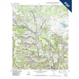
OFM0226. Geologic Map of the Bee Cave Quadrangle, Texas, by E. W. Collins. Oversize geologic map on a color topographic base, scale 1:24,000, 2016. Paper map. To purchase this map as a downloadable PDF, please order OFM0226D.
About This Map
This map illustrates the geology for an area at the dissected eastern margin of the Edwards Plateau that has been experiencing rapid development and population increases for a number of years. Topographic relief is about 650 ft. Geology of the area consists of about 600 ft of Lower Cretaceous shelf and shore-zone deposits of the Glen Rose, Walnut, and Edwards units. Terrace deposits of the Colorado River (upper reaches of Lake Austin in this area) and Barton and Little Barton Creeks are also displayed.
Keywords: maps, geologic maps, Bee Cave area, Central Texas, Edwards Plateau, Texas
Citation
Collins, E. W., 2016, Geologic Map of the Bee Cave Quadrangle, Texas: The University of Texas at Austin, Bureau of Economic Geology, Open-File Map No. 226, map scale 1:24,000.