STATEMAP Project Maps
-
Books & Reports
- Reports of Investigations
- Guidebooks
- Udden Series
- Geological Circulars
- Down To Earth
- Atlases of Major Oil and Gas Reservoirs
- Texas Memorial Museum Publications
- Environmental Geologic Atlas of the Texas Coastal Zone
- Mineral Resource Circulars
- Other Reports
- Seminars and Workshops
- Handbooks
- Submerged Lands of Texas
- Symposia
- Annual Reports
- Open File Reports
-
Maps & Cross Sections
- Thematic Maps
- Miscellaneous Maps, Charts & Sections
- Geologic Atlas of Texas
- STATEMAP Project Maps
- Geologic Quadrangle Maps
- Cross Sections
- Highway Geology Map
- Energy and Mineral Resource Maps
- Shoreline Change and Other Posters
- Wilcox Group, East Texas, Geological / Hydrological Folios
- Bouguer Gravity Atlas of Texas
- River Basin Regional Studies
- Featured Maps
- Posters
- Teachers & the Public
-
Geological Society Publications
- Gulf Coast Association of Geological Societies
- Alabama Geological Society
- Austin Geological Society
- Corpus Christi Geological Society
- Houston Geological Society
- Lafayette Geological Society
- Mississippi Geological Society
- New Orleans Geological Society
- South Texas Geological Society
- GCS SEPM Publications
- Historic BEG & UT Series


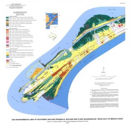
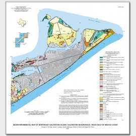
Central Galveston Island, Lake Como quadrangle, Texas
OFM0173
Geoenvironmental Map of Central Galveston Island, Lake Como Quadrangle, Texas Gulf of Mexico Coast, by T. A. Tremblay, J. C. Gibeaut, W. A. White, R. L. Waldinger, and E. W. Collins, 2006. Oversize color map, scale 1:24,000. Print Version.
For a downloadable, digital version: OFM0173D.
For a downloadable, digital version: OFM0173D.
OFM0173. Geoenvironmental map of central Galveston Island, Lake Como quadrangle, Texas Gulf of Mexico Coast, by T. A. Tremblay, J. C. Gibeaut, W. A. White, R. L. Waldinger, and E. W. Collins, 2006. Oversize color map, scale 1:24,000. For PDF: OFM0173D.
Keywords: maps, geoenvironmental maps, Galveston Island, Lake Como area, Texas Coast, Texas
Citation
Tremblay, T. A., Gibeaut, J. C., White, W. A., Waldinger, R. L., and Collins, E. W., 2006, Geoenvironmental Map of Central Galveston Island, Lake Como Quadrangle, Texas Gulf of Mexico Coast: The University of Texas at Austin, Bureau of Economic Geology, Open-File Map No. 173, map scale 1:24,000.