STATEMAP Project Maps
-
Books & Reports
- Reports of Investigations
- Guidebooks
- Udden Series
- Geological Circulars
- Down To Earth
- Atlases of Major Oil and Gas Reservoirs
- Texas Memorial Museum Publications
- Environmental Geologic Atlas of the Texas Coastal Zone
- Mineral Resource Circulars
- Other Reports
- Seminars and Workshops
- Handbooks
- Submerged Lands of Texas
- Symposia
- Annual Reports
- Open File Reports
-
Maps & Cross Sections
- Thematic Maps
- Miscellaneous Maps, Charts & Sections
- Geologic Atlas of Texas
- STATEMAP Project Maps
- Geologic Quadrangle Maps
- Cross Sections
- Highway Geology Map
- Energy and Mineral Resource Maps
- Shoreline Change and Other Posters
- Wilcox Group, East Texas, Geological / Hydrological Folios
- Bouguer Gravity Atlas of Texas
- River Basin Regional Studies
- Featured Maps
- Posters
- Teachers & the Public
-
Geological Society Publications
- Gulf Coast Association of Geological Societies
- Alabama Geological Society
- Austin Geological Society
- Corpus Christi Geological Society
- Houston Geological Society
- Lafayette Geological Society
- Mississippi Geological Society
- New Orleans Geological Society
- South Texas Geological Society
- GCS SEPM Publications
- Historic BEG & UT Series


Shingle Hills-Dripping Springs-Driftwood-Rough Hollow-Henly-Hammetts Crossing Area. Digital Download
OFM0231D
For a print version: OFM0231.
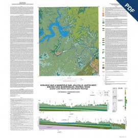
OFM0231D. Geologic Map of the Shingle Hills-Dripping Springs-Driftwood-Rough Hollow-Henly-Hammetts Crossing Area, Central Texas, by E. W. Collins. Oversize color map, scale 1:50,000, 2017. Downloadable PDF. For paper format: OFM0231.
About This Publication
Geology illustrated on this map is based on field and aerial-photograph interpretations following a review of previous work on the area’s geology. Previous regional maps include the 1:250,000-scale Austin Sheet (Proctor and others, 1974) and Llano Sheet (Barnes, 1981). Other geologic maps reviewed include a Master’s thesis map, 1:24,000, by Grimshaw (1970) for the Wimberley area, a 1:125,000-scale map of Hays County by DeCook (1963), and a 1:24,000-scale map of the Hammetts Crossing quadrangle by Barnes (1982a). Bureau of Economic Geology open-file maps of the Shingle Hills, Dripping Springs, Driftwood, Rough Hollow, and Henly quadrangles (Collins, 2002a, b, c, d, e), scale, 1:24,000, were produced for previous STATEMAP work (award number 01HQAG0039) and incorporated into this 2016–2017 study.
Additional new mapping subdivision of the Glen Rose Formation was done this project year. The study benefited from the subsurface and outcrop interpretations described in The Hydrogeologic Atlas of the Hill Country Trinity Aquifer, Blanco, Hays, and Travis Counties, Central Texas (Wierman and others, 2010), a key source of information for any geologic and hydrologic study in the area. Geologic guidebooks that aided the study are by Wermund and Barnes (2003), Hunt and others (2007), and Hunt and others (2011). Geology along the Blanco River in the southwest part of the map was adapted from DeCook (1963) and Stricklin and others (1971). The topographic base was created from digital files of the Texas Natural Resources Information Services (TNRIS) for U.S. Geological Survey, Shingle Hills, Dripping Springs, Driftwood, Rough Hollow, Henly, and Hammetts Crossing, Texas, 7.5-minute topographic quadrangle maps. Digital files of roads, railroads, county boundaries, drainage, and lakes were also obtained through TNRIS.
Work for this map was funded in part by the U.S. Geological Survey National Cooperative Geologic Mapping Program under STATEMAP award numbers G16AC00194, 2016, and 01HQAG0039, 2001, and by the Bureau of Economic Geology STARR program. The study also benefited from work in nearby areas funded in part by the U.S. Geological Survey National Cooperative Geologic Mapping Program under STATEMAP award number G15AC00250.
Keywords: Blanco County, Hays County, Travis County, Central Texas, maps, geologic maps, Shingle Hills, Dripping Springs, Driftwood, Rough Hollow, Henly, Hammetts Crossing, Texas
Citation
Collins, E. W., 2017, Geologic Map of the Shingle Hills-Dripping Springs-Driftwood-Rough Hollow-Henly-Hammetts Crossing Area, Central Texas: The University of Texas at Austin, Bureau of Economic Geology Open-File Map No. 231, map scale 1:50,000.