Bureau of Economic Geology Publications
| Title | Publication Year Sort ascending | Abstract | Author | Publisher | |
|---|---|---|---|---|---|
|
Hydrogeologic and hydrochemical properties of salt-dissolution zones, Palo Duro basin, Texas panhandle - preliminary assessment | 1987 | Ground water that moves downward from aquifers in clastic rocks of the Triassic Dockum Group and Neogene Ogallala Formation dissolves bedded halite and anhydrite in the Upper Permian evaporite section along the perimeter of the Southern High Plains in the Texas Panhandle. |
Dutton, A.R. | Bureau of Economic Geology |
|
Origin and evolution of deep-basin brines, Palo Duro basin, Texas | 1987 | Porous and permeable strata of the Deep-Basin Brine aquifer underlie bedded evaporites that are being considered as repositories for high-level nuclear waste isolation in the Palo Duro Basin, Texas Panhandle. Formation-water samples collected from four U.S. |
Fisher, R.S., Kreitler, C.W. | Bureau of Economic Geology |
|
A saponite and chlorite-rich clay assemblage in Permian evaporite and red-bed strata, Palo Duro basin, Texas panhandle | 1987 | Permian strata in the Palo Duro Basin consist of multicyclic sequences of carbonate, nodular and laminated anhydrite, bedded halite, chaotic mudstone-halite, and terrigenous clastic sediments. |
Palmer, D.P. | Bureau of Economic Geology |
|
Landsat-based lineament analysis, East Texas basin and Sabine uplift area | 1987 | Lineament analysis was used to study the relationship between subsurface structure and surficial features in East Texas, southeastern Oklahoma, southwestern Arkansas, and northwestern Louisiana-areas of low topographic relief, moderate vegetation cover, and diverse land use. |
Baumgardner, R.W., Jr. | Bureau of Economic Geology |
|
Can the U.S. Oil and Gas Resource Base Support Sustained Production? | 1987 | Fisher, W.L. | Bureau of Economic Geology | |
|
Characterization of the Grayburg Reservoir, university lands Dune field, Crane County, Texas | 1987 | San Andres and Grayburg reservoirs have yielded about 42 percent (9.8 billion barrels) of the total cumulative production of oil from the Permian Basin of West Texas. |
Bebout, D.G., Lucia, F.J., Hocott, C.R., Fogg, G.E., Vander Stoep, G.W., Harrington, K.L., Holtz, M.H., Leary, D.A. | Bureau of Economic Geology |
|
Rock Fabric, Permeability, and Log Relationships in an Upward-Shoaling, Vuggy Carbonate Sequence | 1987 | Permeability in a vuggy carbonate sequence can be related to particle size, separate-vug porosity, and interparticle porosity. |
Lucia, F.J., Conti, R.D. | Bureau of Economic Geology |
|
Submerged lands of Texas, Beaumont - Port Arthur area: sediments, geochemistry, benthic macroinvertebrates, and associated wetlands | 1987 | The State-owned submerged lands of Texas encompass almost 6,000 mi2 (15,540 km2). They lie below waters of the bay-estuary-lagoon system and the Gulf of Mexico and extend 10.3 mi (16.6 km) seaward from the Gulf shoreline (fig. 1). |
White, W.A., Calnan, T.R., Morton, R.A., Kimble, R.S., Littleton, T.G., McGowen, J.H., Nance, H.S. | Bureau of Economic Geology |
|
Structure-contour map on the Lower Permian Red Cave Formation, Panhandle Field and adjacent areas of the Texas Panhandle | 1987 | Budnik, R.T. | Bureau of Economic Geology | |
|
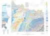
Geologic Atlas of Texas, Wichita Falls-Lawton sheet | 1987 | Geologic map that depicts the surface geology of Hardeman, Wilbarger, Wichita, Clay, Knox, Baylor, Archer, Haskell, Throckmorton, Young, and Foard Counties and part of Jack County, Texas. The 20-page booklet indicates geologic formations, abbreviations, and ages. |
Barnes, V.E., Hentz, T.F., Brown, L.F., Jr., Cleaves, A.W., Kier, R.S., McGowen, J.H., Parrish, W.C., Ramsey, J.W. | Bureau of Economic Geology |