Publications by Budnik, R.T.
| Title | Publication Year Sort ascending | Abstract | Author | Series | Publisher | |
|---|---|---|---|---|---|---|
|
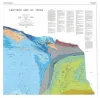
Tectonic map of Texas | 1990 | 4 oversized sheets, Lambert Conformal Conic projection based on standard parallel 33 degrees and 45 degrees. Accompanied by a text booklet, The Tectonic Framework of Texas. |
Ewing, T.E., Budnik, R.T., Ames, J.T., Ridner, D.M., Dillon, R.L. | Thematic Maps | Bureau of Economic Geology |
|
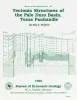
Tectonic structures of the Palo Duro basin, Texas panhandle | 1989 | The Palo Duro Basin is a broad structural low in the southern Texas Panhandle that formed as a result of nearly continuous Pennsylvanian and Permian subsidence. True complexity of this basin is unknown because of the sparsity of structural information. |
Budnik, R.T. | Report of Investigations | Bureau of Economic Geology |
|
Structure-contour map on the Lower Permian Red Cave Formation, Panhandle Field and adjacent areas of the Texas Panhandle | 1987 | Budnik, R.T. | Miscellaneous Map | Bureau of Economic Geology | |
|
Geology and geohydrology of the Palo Duro basin, Texas panhandle -- a report on the progress of nuclear waste isolation feasibility studies (1982) | 1983 | Since early 1977, the Bureau of Economic Geology has been evaluating several salt-bearing basins within the State of Texas as part of the national nuclear waste repository program, The Bureau, a research unit of The University of Texas at Austin, is conducting a long-term program to gather and in |
Gustavson, T.C., Kreitler, C.W., Bassett, R.L., Budnik, R.T., Ruppel, S.C., Baumgardner, R.W., Jr., Caran, S.C., Collins, E.W. | Geological Circular | Bureau of Economic Geology |
|
Geology and geohydrology of the Palo Duro basin, Texas panhandle -- a report on the progress of nuclear waste isolation feasibility studies (1981), annual report for period October 1, 1980 - September 30, 1981 | 1982 | Integrated study of the basin structure, tectonic history, rock physics, physical stratigraphy, hydrogeology, geochemistry, natural resources, and geomorphology of the Palo Duro and Dalhart Basins in the Texas Panhandle is part of a national evaluation of ancient salt basins as potential sites fo |
Gustavson, T.C., Bassett, R.L., Budnik, R.T., Finley, A.C., Goldstein, A.G., McGowen, J.H., Roedder, E., Ruppel, S.C. | Geological Circular | Bureau of Economic Geology |