Publications in Lampasas
| Title | Publication Year Sort ascending | Abstract | Author | Series | Publisher | |
|---|---|---|---|---|---|---|
|
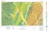
Geologic Map of the Gorman Falls Quadrangle, San Saba, Lampasas and Burnet Counties, Texas | 2025 | Hunt, B.B., Helper, M.A. | Open-File Map | Bureau of Economic Geology | |
|
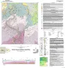
Geologic Atlas of Texas, Brownwood sheet | 1976 | Geologic map that depicts the surface geology of Mills County and parts of Runnels, Coleman, Brown, Comanche, Erath, Hamilton, Coryell, Lampasas, San Saba, McCulloch, Concho, and Menard Counties. The 21-page booklet indicates geologic formations, abbreviations, and ages. |
Kier, R.S., Harwood, P., Brown, L.F., Jr., Goodson, J.L., Barnes, V.E., Shell Oil Co., Humble Oil and Refining Co., Southern Minerals Corp. | Geologic Atlas of Texas | Bureau of Economic Geology |
|
Pre-Chappel conodonts of the Llano region, Texas | 1970 | This work was begun in 1964 and substantially completed in 1965; at that time conodont zones had been established in North America only for the Upper Devonian, by Clark and Becker (1960) for the Great Basin and Collinson, Scott, and Rexroad (1962) for the mid-continent. |
Seddon, George | Report of Investigations | Bureau of Economic Geology |
|
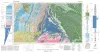
Geologic Atlas of Texas, Waco sheet | 1970 | Geologic maps that depicts the surface geology of McLennan, Limestone, and Falls Counties and parts of Bosque, Hill, Navarro, Freestone, Leon, Madison, Robertson, Milam, Bell, Lampasas, Coryell, and Hamilton Counties, Texas. |
Barnes, V.E., Humble Oil and Refining Co., Shell Oil Co., Mobil Oil Co., Proctor, C.V., Jr., McGowen, J.H., Haenggi, W.T., Hayward, O.T. | Geologic Atlas of Texas | Bureau of Economic Geology |
|
Nomenclature revision of basal Cretaceous rocks between the Colorado and Red Rivers, Texas | 1966 | Based on need for convenient, small-scale cartographic units, the basal Cretaceous rocks in Texas from Red River to Burnet County and on the Callahan Divide are herein divided into three distinctive lithologic sequences. |
Fisher, W.L., Rodda, P.U. | Report of Investigations | Bureau of Economic Geology |
|
Stratigraphy of the Fredericksburg Division, south-central Texas | 1964 | Sediments of the Fredericksburg Division in south-central Texas were deposited on the slowly subsiding west flank of the Tyler basin. In this region there are three stratigraphically distinct areas. The southern area has a thick Edwards Limestone unit overlying a thin Walnut Formation. |
Moore, C.H. | Report of Investigations | Bureau of Economic Geology |
|
Devonian - Mississippian transition in central Texas | 1957 | The Devonian-Mississippian transition outcrops of central Texas are here described summarily and assigned to a new stratigraphic unit, the Houy Formation. The beds included are mainly Upper Devonian, but partly Lower Mississippian. Locally a basal fraction may be Middle Devonian. |
Cloud, P.E., Jr., Barnes, V.E., Hass, W.H. | Report of Investigations | Bureau of Economic Geology |
|
The Carboniferous Rocks of the Llano Region of Central Texas | 1950 | Plummer, F.B. | UT Publication | ||
|
Building Stones of Central Texas | 1942 | Barnes, V.E., Dawson, R.F., Parkinson, G.A. | UT Publication | ||
|
Stratigraphic and structural studies in north central Texas | 1929 | Cheney, M.G. | UT Bulletin |