|
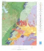
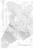
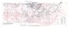
Geologic Map of the Austin Area, Color map, Plate VII of RI 86 |
Garner, L.E. |
1976 |
Miscellaneous Map |
|
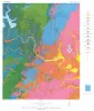
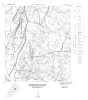
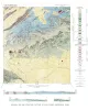
Rock-type Map of the Austin area, Plate I of RI 86 |
Garner, L.E. |
1976 |
Miscellaneous Map |
![Texas Mining Laws Pertaining to State Public Lands [as of 1968]](/files/styles/thumbnail/public/publication_covers/MM0033.jpg.webp?itok=fb274W2W)
|
Texas Mining Laws Pertaining to State Public Lands [as of 1968] |
Leach, C.H. |
1968 |
Miscellaneous Map |
|
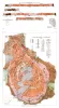
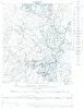
Geologic map of the Big Bend National Park, Brewster County, Texas |
Maxwell, R.A. |
1966 |
Miscellaneous Map |

|
Correlation of Cambrian Rocks in Central Texas |
Barnes, V.E. |
1963 |
Miscellaneous Map |
|
Index to Areal Geologic Maps in Texas |
Brown, T.E. |
1963 |
Miscellaneous Map |
|
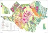
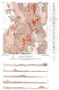
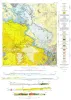
Geologic map of Southeastern Llano Uplift, Llano, Burnet, Blanco, and Gillespie counties, Texas |
McGehee, R.V. |
1963 |
Miscellaneous Map |
|
Geologic Maps, Central Texas (selected areas), 1957 and 1959 |
Whitney, F.L. |
1957 |
Miscellaneous Map |
|
Enchanted rock batholith, Llano and Gillespie Counties, Texas |
Hutchinson, R.M. |
1956 |
Miscellaneous Map |
|
Cathedral Mountain quadrangle, Brewster County, Texas |
McAnulty, W.N. |
1955 |
Miscellaneous Map |
|
Map showing correlation of geologic, gravity, and magnetic observations, Blanco and Gillespie Counties, Texas |
Barnes, V.E., Romberg, Frederick, Anderson, W.A. |
1955 |
Miscellaneous Map |

|
Cross section, Post-Ellenburger beds, Coke, Runnels, Coleman, and Brown Counties, Texas |
Morey, P.S. |
1955 |
Miscellaneous Map |
|
Geologic Map and Structure Sections of Hood Spring Quadrangle, Texas |
Graves, R.W. |
1954 |
Miscellaneous Map |
|
Geologic map of Chinati Peak quadrangle, Presidio County, Texas |
Rix, C.C. |
1953 |
Miscellaneous Map |
|
Tascotal Mesa Quadrangle, Brewster and Presidio Counties, Texas |
Erickson, R.L. |
1953 |
Miscellaneous Map |
|
Edwards Core Study |
Feray, D.E., Jr. |
1952 |
Miscellaneous Map |
|
Geologic map and structure sections of the Christmas and Rosillos Mountains, Brewster County, Texas |
Bloomer, R.R. |
1951 |
Miscellaneous Map |
|
Agua Fria quadrangle, Brewster County, Texas |
Moon, C.G. |
1951 |
Miscellaneous Map |
|
Map of oil, gas, and distillate fields of Texas, December 1945 |
Hendricks, Leo |
1949 |
Miscellaneous Map |
|
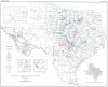
Structural Map of Texas |
Sellards, E.H., McCarter, C.E. |
1946 |
Miscellaneous Map |