|
Houston County geologic maps |
Stenzel, H.B., Hurlbut, E.M. |
1944 |
Miscellaneous Map |

|
Mineral Locality Map of Texas |
Sellards, E.H., Evans, G.L., Hendricks, Leo |
1944 |
Miscellaneous Map |

|
Geologic map of San Saba County, Texas, south of 31 degrees 21minutes latitude |
Plummer, F.B. |
1940 |
Miscellaneous Map |

|
Maps of Cambrian; Devonian; Upper, Middle, and Lower Ordovician; and Silurian Formations in Texas |
Sellards, E.H. |
1938 |
Miscellaneous Map |

|
Geologic Map of Leon County, Texas |
Stenzel, H.B. |
1938 |
Miscellaneous Map |

|
Geologic map of Parker County, Texas |
Armstrong, J.M., Scott, Gayle |
1937 |
Miscellaneous Map |

|
Geologic map of Denton County, Texas |
Winton, W.M., Hawley, J.B. |
1935 |
Miscellaneous Map |

|
Geologic map of the Solitario |
Sellards, E.H., Adkins, W.S., Arick, M.B. |
1933 |
Miscellaneous Map |

|
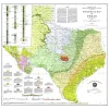
Geologic Map of Texas (1933) |
University of Texas at Austin, Bureau of Economic Geology |
1933 |
Miscellaneous Map |

|
Map of Paleozoic of Ouachita Facies in Texas |
Sellards, E.H. |
1932 |
Miscellaneous Map |

|
Plane table map of Reynosa Escarpment in parts of Jim Hogg, Starr and Zapata counties, Texas |
Wilson, J.M. |
1932 |
Miscellaneous Map |

|
Selected Texas County Maps, 1929-1937 |
|
1929 |
Miscellaneous Map |

|
Pennsylvanian and Permian Formations of North-Central Texas |
|
1929 |
Miscellaneous Map |

|
Geology of Texas Map, 1916 |
Udden, J.A., Baker, C.L., Bose, E. |
1919 |
Miscellaneous Map |

|
Southwest Upton County sheet, Texas |
Liddle, R.A., Prettyman, T.M., Thompson, V., Christner, D.D., Dodson, F.C., Bowman, C.E. |
1919 |
Miscellaneous Map |

|
Geological map of a portion of west Texas |
Hill, B.F., Udden, J.A. |
1904 |
Miscellaneous Map |