Publications in Gillespie
| Title | Publication Year Sort ascending | Abstract | Author | Series | Publisher | |
|---|---|---|---|---|---|---|
|
Factors Influencing Rock Strength and Fluid Flow at the Basement–Sediment Interface from Field and Core-Based Observations, Llano Uplift, Texas | 2023 | The hydromechanical properties of the uppermost basement and of the basement–sediment interface influence multiple geologic processes of societal relevance, including the flow of groundwater; the accumulation of hydrocarbons, economic minerals, and geothermal resources; and the response of seismo |
Callahan, O.A., Eichhubl, Peter, Kyle, J.R. | Report of Investigations | Bureau of Economic Geology |
|
Petrography and diagenesis of a half-billion-year-old cratonic sandstone (Hickory), Llano region, Texas | 2002 | We studied the Hickory Sandstone Member of the Riley Formation, Central Texas, to assess the diagenetic history of a cratonic sandstone, which, in spite of its great age, remains porous and permeable where it has not been buried more than 1 km. |
McBride, E.F., Abdel-Wahab, A.A., Milliken, K.L. | Report of Investigations | Bureau of Economic Geology |
|
Pavement Deflection and Seismic Refraction for Determining Bedrock Type, Depth, and Physical Properties beneath Roads | 2000 | We examined the relationship between three data types--geologic maps, measurements of pavement deflection under load, and seismic refraction data-- from diverse geologic settings in Texas to determine (1) whether geologic maps and seismic refraction data might be used to interpret deflections and |
Paine, J.G., Murphy, M.R. | Report of Investigations | Bureau of Economic Geology |
|
The dimension stone industry of Texas | 1992 | Garner, L.E. | Mineral Resource Circular | Bureau of Economic Geology | |
|
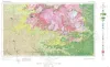
Geologic Atlas of Texas, Llano sheet | 1981 | Geologic map that depicts the surface geology of Mason, Llano, and Gillespie Counties and parts of Menard, Kimble, San Saba, McCulloch, Edwards, Real, Kerr, Kendall, Blanco, Hays, Travis, Williamson, and Burnet Counties, Texas. |
Barnes, V.E., Shell Oil Co., Boyer, R.E., Clabaugh, S.E., Baker, E.T. | Geologic Atlas of Texas | Bureau of Economic Geology |
|
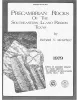
Precambrian rocks of the southeastern Llano region, Texas | 1979 | Precambrian sedimentary rocks and associated mafic and silicic igneous rocks in Central Texas underwent a single episode of regional metamorphism about 1,050 million years (m.y.) ago. |
McGehee, R.V. | Geological Circular | Bureau of Economic Geology |
|
The Moore Hollow Group of central Texas | 1977 | Middle and Upper Cambrian rocks and locally up to 90 feet of Lower Ordovician rocks in Central Texas, are here named the Moore Hollow Group. |
Barnes, V.E., Bell, W.C. | Report of Investigations | |
|
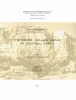
Geology of the Llano region and Austin area: field excursion | 1972 | This Guidebook represents an updating of Bureau of Economic Geology Guidebook No. 5, Field Excursion-Geology of Llano Region and Austin Area. It also represents a modification of Geology of the Llano Region and Austin Area, Texas, published by the Shreveport Geological Society in 1971. |
Barnes, V.E., Bell, W.C., Clabaugh, S.E., Cloud, P.E., Jr., McGehee, R.V., Rodda, P.U., Young, Keith | Guidebook | Bureau of Economic Geology |
|
Stratigraphy of Lower Cretaceous Trinity deposits of central Texas | 1971 | The stratigraphic record of the Lower Cretaceous Trinity Division in Central Texas, as revealed by extensive outcrop investigation, is that of a shallow sea transgressing the southern flank of the ancient Llano Uplift. |
Stricklin, F.L., Smith, C.I., Lozo, F.E. | Report of Investigations | Bureau of Economic Geology |
|
Trilobites of the Upper Cambrian Ptychaspid biomere, Wilberns Formation, central Texas | 1970 | Trilobites collected during the past 20 years from the Morgan Creek, Point Peak, and San Saba Members of the Wilberns Formation comprise 89 species assigned to 45 genera belonging to zones of the upper Franconian and Trempealeauan Stages of the Upper Cambrian Croixan Series. |
Longacre, S.A. | Report of Investigations | Bureau of Economic Geology |