Publications in Kimble
| Title | Publication Year Sort ascending | Abstract | Author | Series | Publisher | |
|---|---|---|---|---|---|---|
|
Geologic map of the Turtle Creek Quadrangle, Mason County, Texas | 2022 | Hunt, B.B., Johnson, B., Helper, M.A., Droxler, A. | Open-File Map | Bureau of Economic Geology | |
|
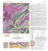
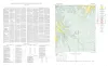
Geologic Atlas of Texas, Llano sheet | 1981 | Geologic map that depicts the surface geology of Mason, Llano, and Gillespie Counties and parts of Menard, Kimble, San Saba, McCulloch, Edwards, Real, Kerr, Kendall, Blanco, Hays, Travis, Williamson, and Burnet Counties, Texas. |
Barnes, V.E., Shell Oil Co., Boyer, R.E., Clabaugh, S.E., Baker, E.T. | Geologic Atlas of Texas | Bureau of Economic Geology |
|
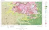
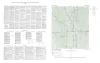
Geologic Atlas of Texas, Sonora sheet | 1981 | Geologic map that depicts the surface geology of Sutton County and parts of Terrell, Crockett, Val Verde, Edwards, Kimble, Menard, Schleicher, and Pecos Counties. |
Barnes, V.E., McKalips, D.G., Cities Service Petroleum Co., Geophoto Services Inc., Stump, R.W., Brown, J.B., Pearson, B.T., Volkmann, R.G. | Geologic Atlas of Texas | Bureau of Economic Geology |
|
Stratigraphy of Lower Cretaceous Trinity deposits of central Texas | 1971 | The stratigraphic record of the Lower Cretaceous Trinity Division in Central Texas, as revealed by extensive outcrop investigation, is that of a shallow sea transgressing the southern flank of the ancient Llano Uplift. |
Stricklin, F.L., Smith, C.I., Lozo, F.E. | Report of Investigations | Bureau of Economic Geology |
|
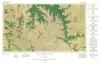
Geologic map of the Fall Prong Quadrangle, Kimble, Gillespie and Mason Counties, Texas | 1956 | Fall Prong quadrangle is in the marginal portion of the Edwards Plateau near the southeastern corner of the Llano region. Almost three-quarters of the quadrangle is within the Edwards Plateau, and the rest consists of valleys of the Llano basin cutting back into the plateau. |
Barnes, V.E. | Geologic Quadrangle Map | Bureau of Economic Geology |
| |
Map showing correlation of geologic, gravity, and magnetic observations, Blanco and Gillespie Counties, Texas | 1955 | Barnes, V.E., Romberg, Frederick, Anderson, W.A. | Miscellaneous Map | Bureau of Economic Geology | |
|
Geologic map of the Wendel Quadrangle, Kimble, Kerr, and Gillespie Counties, Texas | 1954 | Wendel quadrangle is entirely within the Edwards Plateau province and is situated southwest of the Llano region. |
Barnes, V.E. | Geologic Quadrangle Map | Bureau of Economic Geology |
|
The Carboniferous Rocks of the Llano Region of Central Texas | 1950 | Plummer, F.B. | UT Publication | ||

|
Well Records of Kimble County Texas | 1928 | These circulars issued from the Bureau of Economic Geology contain the record of cores and cuttings from well received and described in the Bureau. |
Well Record |