Fall Prong Quadrangle Publications
| Title | Publication Year Sort ascending | Abstract | Author | Series | Publisher | |
|---|---|---|---|---|---|---|
|
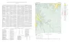
Geologic map of the Fall Prong Quadrangle, Kimble, Gillespie and Mason Counties, Texas | 1956 | Fall Prong quadrangle is in the marginal portion of the Edwards Plateau near the southeastern corner of the Llano region. Almost three-quarters of the quadrangle is within the Edwards Plateau, and the rest consists of valleys of the Llano basin cutting back into the plateau. |
Barnes, V.E. | Geologic Quadrangle Map | Bureau of Economic Geology |