|
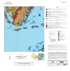
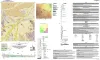
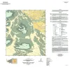
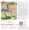
Geologic map of the Port Ingleside quadrangle, Texas Gulf coast |
Paine, J.G., Caudle, T.L., Morris, J.N., Grunau, B.A. |
2025 |
Open-File Map |
|
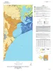
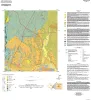
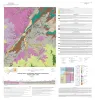
Geologic map of the Cove and Umbrella Point quadrangles, Texas Gulf coast |
Caudle, T.L., Paine, J.G. |
2025 |
Open-File Map |
|
Geologic map of the Mesquite Bay area, Texas Gulf Coast |
Paine, J.G., Caudle, T.L., Grunau, B.A., Morris, J.N. |
2025 |
Open-File Map |
|
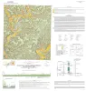
Geologic map of the Taft area, Texas Gulf Coast |
Paine, J.G., Morris, J.N., Grunau, B.A. |
2025 |
Open-File Map |
|
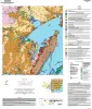
Geologic Map of Trinity Bay, Texas Gulf coast |
Caudle, T.L., Paine, J.G. |
2025 |
Open-File Map |
|
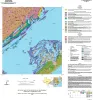
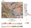
Geologic map of the Copano Bay area, Texas Gulf Coast |
Paine, J.G., Collins, E.W., Costard, L., Grunau, B.A., Morris, J.N., Caudle, T.L. |
2025 |
Open-File Map |
|
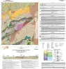
Bedrock Geologic Map of the Fly Gap Quadrangle, Mason County, Texas |
Hunt, B.B., Helper, M.A., Droddy, Jr., M.J. |
2025 |
Open-File Map |
|
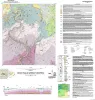
Geologic Map of the Gorman Falls Quadrangle, San Saba, Lampasas and Burnet Counties, Texas |
Hunt, B.B., Helper, M.A. |
2025 |
Open-File Map |
|
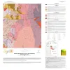
Geologic Map of the Toyahvale Quadrangle, Jeff Davis and Reeves Counties, Texas |
Hunt, B.B., Helper, M.A., Horne, E.A., Hennings, P.H., Rhoden, E. |
2025 |
Open-File Map |
|
Geologic map of the Austin East quadrangle, Travis County, Texas |
Morris, J.N., Woodruff, C.M., Jr., Grunau, B.A. |
2025 |
Open-File Map |
|
Geologic map of the Diablo Canyon East quadrangle, Hudspeth County, Texas |
Elliott, Brent A., Short, S.R., Ugurhan, M. |
2025 |
Open-File Map |
|
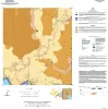
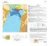
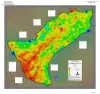
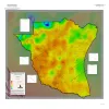
Geothermal Resources, Onshore Gulf Coast Texas |
Andrews, J.R. |
2025 |
Open-File Map |
|
Geologic map of the Norton Mesa quadrangle, Texas |
Elliott, Brent A. |
2024 |
Open-File Map |
|
Geothermal Resources, South Texas |
Andrews, J.R. |
2024 |
Open-File Map |
|
Geologic map of the Loyal Valley quadrangle, Mason County, Texas |
Hunt, B.B., Helper, M.A., Morris, J.N., Mutis-Duplat, Emilio, Gray, M.W. |
2024 |
Open-File Map |
|
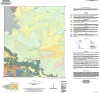
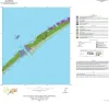
Geologic map of the Decros Point quadrangle, Texas Gulf Of Mexico Coast |
Morris, J.N., Paine, J.G. |
2024 |
Open-File Map |
|
Geologic map of the Panther Creek quadrangle, Mason County, Texas |
Hunt, B.B. |
2023 |
Open-File Map |
|
Geologic map of the Monument Mountain SE quadrangle, Mason County, Texas |
Hunt, B.B. |
2023 |
Open-File Map |
|
Geologic map of the Dolan Springs quadrangle, Val Verde County, Texas |
Hunt, B.B., Andrews, J.R., Paine, J.G. |
2023 |
Open-File Map |
|
Geologic map of a Portion of the Southeastern Llano Uplift, Burnet, Llano, and Blanco Counties Texas |
Helper, M.A., Hunt, B.B., Barnes, V.E. |
2023 |
Open-File Map |