Miscellaneous Maps, Charts & Sections
-
Books & Reports
- Reports of Investigations
- Guidebooks
- Udden Series
- Geological Circulars
- Down To Earth
- Atlases of Major Oil and Gas Reservoirs
- Texas Memorial Museum Publications
- Environmental Geologic Atlas of the Texas Coastal Zone
- Mineral Resource Circulars
- Other Reports
- Seminars and Workshops
- Handbooks
- Submerged Lands of Texas
- Symposia
- Annual Reports
- Open File Reports
-
Maps & Cross Sections
- Thematic Maps
- Miscellaneous Maps, Charts & Sections
- Geologic Atlas of Texas
- STATEMAP Project Maps
- Geologic Quadrangle Maps
- Cross Sections
- Highway Geology Map
- Energy and Mineral Resource Maps
- Shoreline Change and Other Posters
- Wilcox Group, East Texas, Geological / Hydrological Folios
- Bouguer Gravity Atlas of Texas
- River Basin Regional Studies
- Featured Maps
- Posters
- Teachers & the Public
-
Geological Society Publications
- Gulf Coast Association of Geological Societies
- Alabama Geological Society
- Austin Geological Society
- Corpus Christi Geological Society
- Houston Geological Society
- Lafayette Geological Society
- Mississippi Geological Society
- New Orleans Geological Society
- South Texas Geological Society
- GCS SEPM Publications
- Historic BEG & UT Series


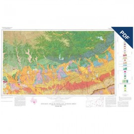
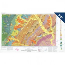
Structure Map of the San Antonio Segment of the Edwards Aquifer. Digital Download
MM0038D
For a print version: MM0038.
MM0038D. Structure Map of the San Antonio Segment of the Edwards Aquifer and Balcones Fault Zone, South-Central Texas: Structural Framework of a Major Limestone Aquifer: Kinney, Uvalde, Bexar, Comal, and Hays Counties, by E. W. Collins and S. D. Hovorka. Oversize color map, scale 1:250,000, and 14-page booklet, 1997. Downloadable PDF
To purchase this map in paper format, please order MM0038.
About This Publication
Normal faults of the Balcones Fault Zone are the principal structural control on the important Edwards limestone aquifer and recharge zone, currently the sole source aquifer of San Antonio, Texas, and many other municipalities in Central Texas. The San Antonio segment of the aquifer, extending over an area of approximately 3,000 mi2 in Kinney, Uvalde, Medina, Bexar, Comal, and Hays Counties, is the main water resource for residential, agricultural, and industrial use in Bexar, Medina, and Uvalde Counties.
The map of the aquifer depicts the subsurface structure of the base of the Del Rio Formation (approximate top of the confined part of the aquifer), the Edwards Group outcrop belt (aquifer recharge area and unconfined part of the aquifer), faults, large relay ramps, and the approximate interface between fresh and saline water. The map builds on many previous studies of the structure and stratigraphy of the Edwards aquifer.
The authors used an updated subsurface data base and recent comprehensive surface geologic mapping conducted by the senior author, however, to illustrate the structure at a scale that provides more detail than that of any map previously available. The authors are thus able to make new interpretations on fault occurrence, throw, and geometry. The accompanying booklet summarizes key elements of the Edwards aquifer's structural framework and describes structural attributes that affect aquifer recharge, ground-water flow, areal extent, and depth.
Keywords: maps, structure maps, San Antonio area, Edwards aquifer, Balcones Fault Zone, Del Rio Formation, Edwards Group, faults, aquifers, Kinney County, Uvalde County, Bexar County, Comal County, Hays County, Texas
Citation
Collins, E. W., and Hovorka, S. D., 1997, Structure Map of the San Antonio Segment of the Edwards Aquifer and Balcones Fault Zone, South-Central Texas: Structural Framework of a Major Limestone Aquifer: Kinney, Uvalde, Bexar, Comal, and Hays Counties: The University of Texas at Austin, Bureau of Economic Geology, Miscellaneous Map No. 38, map scale 1:250,000, and 14-page booklet.