Miscellaneous Maps, Charts & Sections
-
Books & Reports
- Reports of Investigations
- Guidebooks
- Udden Series
- Geological Circulars
- Down To Earth
- Atlases of Major Oil and Gas Reservoirs
- Texas Memorial Museum Publications
- Environmental Geologic Atlas of the Texas Coastal Zone
- Mineral Resource Circulars
- Other Reports
- Seminars and Workshops
- Handbooks
- Submerged Lands of Texas
- Symposia
- Annual Reports
- Open File Reports
-
Maps & Cross Sections
- Thematic Maps
- Miscellaneous Maps, Charts & Sections
- Geologic Atlas of Texas
- STATEMAP Project Maps
- Geologic Quadrangle Maps
- Cross Sections
- Highway Geology Map
- Energy and Mineral Resource Maps
- Shoreline Change and Other Posters
- Wilcox Group, East Texas, Geological / Hydrological Folios
- Bouguer Gravity Atlas of Texas
- River Basin Regional Studies
- Featured Maps
- Posters
- Teachers & the Public
-
Geological Society Publications
- Gulf Coast Association of Geological Societies
- Alabama Geological Society
- Austin Geological Society
- Corpus Christi Geological Society
- Houston Geological Society
- Lafayette Geological Society
- Mississippi Geological Society
- New Orleans Geological Society
- South Texas Geological Society
- GCS SEPM Publications
- Historic BEG & UT Series


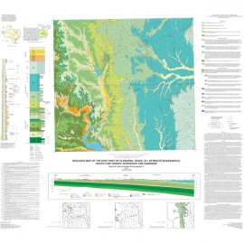
New Braunfels, Texas, 30 x 60 Minute Quadrangle
MM0039
For a downloadable, digital version: MM0039D.
MM0039. Geologic Map of the New Braunfels, Texas, 30 x 60 Minute Quadrangle: Geologic Framework of an Urban-Growth Corridor along the Edwards Aquifer, South-Central Texas, by E. W. Collins. 1 oversized folded color map scale 1:100,000 and 28-p. text, 2000.
To purchase this publication as a PDF download, please order MM0039D.
About This Publication
This map and text set describes the physical geology of an area that is undergoing rapid urban growth. The study area includes part of the regionally important Edwards aquifer and recharge zone. The set also provides general information relating geology to aspects of land use, urban planning, construction practices, and water-resource management. Research for the project was supported by the COGEOMAP Program and the STATEMAP component of the National Cooperative Geologic Mapping Program administered by the U.S. Geological Survey.
Geolocation:
North Latitude: 30° 0' 0" N (30.0000)
South Latitude: 29° 30' 0" N (29.5000)
East Longitude: 98° 0' 0" W (-98.0000)
West Longitude: 99° 0' 0" W (-99.0000)
Keywords: maps, geologic maps, New Braunfels area, south-central Texas, Texas
Citation
Collins, E. W., 2000, Geologic Map of the New Braunfels, Texas, 30 x 60 Minute Quadrangle: Geologic Framework of an Urban-Growth Corridor along the Edwards Aquifer, South-Central Texas: The University of Texas at Austin, Bureau of Economic Geology, Miscellaneous Map No. 39, map scale 1:100,000, and 28-p. text.