Geologic Quadrangle Maps
-
Books & Reports
- Reports of Investigations
- Guidebooks
- Udden Series
- Geological Circulars
- Down To Earth
- Atlases of Major Oil and Gas Reservoirs
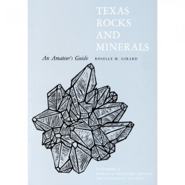
- Texas Memorial Museum Publications
- Environmental Geologic Atlas of the Texas Coastal Zone
- Mineral Resource Circulars
- Other Reports
- Seminars and Workshops
- Handbooks
- Submerged Lands of Texas
- Symposia
- Annual Reports
- Open File Reports
-
Maps & Cross Sections
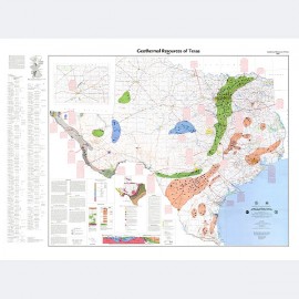
- Thematic Maps
- Miscellaneous Maps, Charts & Sections
- Geologic Atlas of Texas
- STATEMAP Project Maps
- Geologic Quadrangle Maps
- Cross Sections
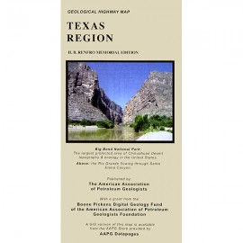
- Highway Geology Map
- Energy and Mineral Resource Maps
- Shoreline Change and Other Posters
- Wilcox Group, East Texas, Geological / Hydrological Folios
- Bouguer Gravity Atlas of Texas
- River Basin Regional Studies
- Featured Maps
- Posters
- Teachers & the Public
-
Geological Society Publications
- Gulf Coast Association of Geological Societies
- Alabama Geological Society
- Austin Geological Society
- Corpus Christi Geological Society
- Houston Geological Society
- Lafayette Geological Society
- Mississippi Geological Society
- New Orleans Geological Society
- South Texas Geological Society
- GCS SEPM Publications
- Historic BEG & UT Series


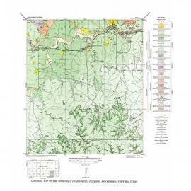
Hye Quadrangle, Blanco, Gillespie, and Kendall Counties, Texas
GQ0027
Geology of the Hye Quadrangle, Blanco, Gillespie, and Kendall Counties, Texas, by V. E. Barnes. Scale 1:24,000; 8-p. text, 1965. Print Version.
A free, digital version of this publication can be found on: Texas ScholarWorks
GQ0027. Geology of the Hye quadrangle, Blanco, Gillespie, and Kendall Counties, Texas, by V. E. Barnes. Scale 1:24,000; 8-p. text, 1965.
General Setting
Hye quadrangle includes part of the southeastern Llano region and part of the eastern margin of the Edwards Plateau where most of the Plateau surface has been destroyed by erosion. In the southern part of the quadrangle a narrow lobe of the Edwards Plateau trends east-northeastward from near the southwest quadrangle corner. The area to the north is in the broad gently rolling Pedernales River basin, and that to the south is in a fairly rugged marginal part of the Blanco River drainage area.
The geology of the Hye quadrangle is shown on a U.S. Geological Survey 7.5-minute topographic quadrangle map and, following the Johnson City quadrangle (Barnes, 1963), is the second geologic map in the Llano region to appear on a modern 1:24,000 scale, 20-foot contour interval base. The relief in the quadrangle is about 591 feet; elevations range from about 1,362 feet where Pedernales River leaves the quadrangle to 1,953 feet near the southwest corner of the quadrangle.
About 80 percent of the Hye quadrangle is drained by Pedernales River, mostly through two main tributaries, Williamson and Rocky Creeks, both of which have three forks--East, Middle, and West-and numerous named and unnamed tributaries. The remaining 20 percent of the quadrangle drains to Blanco River by way of Klepac Creek, Stiner Creek, Murry Branch, Roman Branch, and various unnamed branches. During the time the geology of this area was being mapped, Klepac Creek was known as North Big Creek and Stiner Creek as West Big Creek.
Hye quadrangle is high on the southeastern side of the Llano uplift. Cambrian and Ordovician rocks are represented by about 1 square mile of outcrop. Cretaceous rocks and small Quaternary surficial deposits occupy the remainder. The Cambrian and Ordovician rocks exposed in the northeastern part of the quadrangle dip southeastward at angles up to about 5°, and the relatively flat-lying Cretaceousrocks dip eastward about 10 feet per mile.
Discussion of stratigraphic, structural, economic, and geophysical problems are in cited references. This publication on the Hye quadrangle is one of a series of central Texas geologic quadrangle maps which will be compiled as topographic bases become available. An index map for geologic maps already published on planimetric bases and others planned for publication on the new topographic bases is shown with the geologic map.
During the period 1939 to 1942, the writer, assisted by Louis Dixon, mapped geologically the western one-third of the Hye quadrangle in Gillespie and Kendall counties. Mapping of the remainder of the quadrangle area, in Blanco County, was done intermittently with assistance from L. E. Warren (1942-1946) and A. R. Palmer (1947-1948). A gravity survey of the quadrangle was completed during 1946-1948 with the aid of Louis Dixon and A. R. Palmer.
CONTENTS
General setting
Geologic formations
Paleozoic rocks
Cambrian System (Upper Cambrian)
Wilberns Formation
San Saba Member
Ordovician System (Lower Ordovician)
Ellenburger Group
Tanyard Formation
Threadgill Member
Mesozoic rocks
Cretaceous System (Lower Cretaceous
Trinity Group
Shingle Hills Formation
Hensell Sand Member
Glen Rose Limestone Member
Fredericksburg Group
Walnut Clay
Comanche Peak Limestone
Edwards Limestone
Cenozoic rocks
Quaternary System
Pleistocene Series
High gravel
Recent Series
Alluvium
Subsurface geology
Mineral resources
Construction materials
Dimension stone
Crushed stone
Sand and gravel
Road material
Water
Selected references
Sample description
Nixon-Dore-Power No. 1 Andrew Lindig
Stratigraphic section
Section 3.5 miles southeast of Albert, along Blanco road