Geologic Quadrangle Maps
-
Books & Reports
- Reports of Investigations
- Guidebooks
- Udden Series
- Geological Circulars
- Down To Earth
- Atlases of Major Oil and Gas Reservoirs
- Texas Memorial Museum Publications
- Environmental Geologic Atlas of the Texas Coastal Zone
- Mineral Resource Circulars
- Other Reports
- Seminars and Workshops
- Handbooks
- Submerged Lands of Texas
- Symposia
- Annual Reports
- Open File Reports
-
Maps & Cross Sections
- Thematic Maps
- Miscellaneous Maps, Charts & Sections
- Geologic Atlas of Texas
- STATEMAP Project Maps
- Geologic Quadrangle Maps
- Cross Sections
- Highway Geology Map
- Energy and Mineral Resource Maps
- Shoreline Change and Other Posters
- Wilcox Group, East Texas, Geological / Hydrological Folios
- Bouguer Gravity Atlas of Texas
- River Basin Regional Studies
- Featured Maps
- Posters
- Teachers & the Public
-
Geological Society Publications
- Gulf Coast Association of Geological Societies
- Alabama Geological Society
- Austin Geological Society
- Corpus Christi Geological Society
- Houston Geological Society
- Lafayette Geological Society
- Mississippi Geological Society
- New Orleans Geological Society
- South Texas Geological Society
- GCS SEPM Publications
- Historic BEG & UT Series


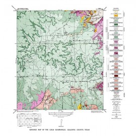
Palo Alto Creek quadrangle, Texas
GQ0008
Geologic Map of the Palo Alto Creek Quadrangle, Gillespie County, Texas, by V. E. Barnes. Oversized color geologic map with text on the back, map scale 1:31,680, 1952. Paper map. Print Version.
A free, digital version of this publication can be found on: Texas ScholarWorks
GQ0008. Geologic Map of the Palo Alto Creek Quadrangle, Gillespie County, Texas, by V. E. Barnes. Oversized color geologic map with text on the back, map scale 1:31,680, 1952.
To purchase this map as a PDF download, please order GQ0008D.
Keywords: maps, geologic maps, quadrangle maps, Palo Alto Creek quadrangle, Gillespie County, Texas
Citation
Barnes, V. E., 1952, Geologic Map of the Palo Alto Creek Quadrangle, Gillespie County, Texas: The University of Texas at Austin, Bureau of Economic Geology, Geologic Quadrangle Map No. 8, scale 1:31,680.